
Make a donation
Gear up for your next adventure:
As an Amazon Associate, this site earns from qualifying purchases at no extra cost to you.
Ann Arbor topographic map
Click on the map to display elevation.
Make a donation
Gear up for your next adventure:
As an Amazon Associate, this site earns from qualifying purchases at no extra cost to you.
Ann Arbor
Ann Arbor features a varied topography characterized by rolling hills and valleys shaped by glacial activity. The city is situated along the Huron River, which carves its way through the landscape, creating steep banks and fertile floodplains. Elevations range from approximately 750 feet (230 meters) along the river to over 1,015 feet (309 meters) in the western regions near Maple Road and Pauline Boulevard. This gradual elevation change contributes to the scenic beauty of the area, with higher terrain predominantly found in the west-central and northwestern parts of the city, including the University of Michigan's North Campus. The region's hills and lush valleys are interspersed with agricultural lands, making it a productive area for farming and fruit growing.
Make a donation
Gear up for your next adventure:
As an Amazon Associate, this site earns from qualifying purchases at no extra cost to you.
About this map
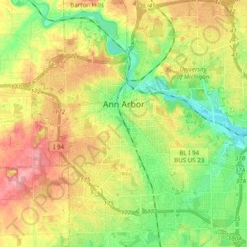
Name: Ann Arbor topographic map, elevation, terrain.
Location: Ann Arbor, Washtenaw County, Michigan, United States (42.22267 -83.79957 42.32389 -83.67581)
Average elevation: 879 ft
Minimum elevation: 732 ft
Maximum elevation: 1,070 ft
Washtenaw County trails, hiking, mountain biking, running and outdoor activities
Make a donation
Gear up for your next adventure:
As an Amazon Associate, this site earns from qualifying purchases at no extra cost to you.
Other topographic maps
Click on a map to view its topography, its elevation and its terrain.
Rawsonville
United States > Michigan > Washtenaw County > Ypsilanti Charter Township
Average elevation: 702 ft
Frain Lake
United States > Michigan > Washtenaw County > Superior Charter Township
Average elevation: 850 ft
Rawsonville
United States > Michigan > Washtenaw County > Ypsilanti Charter Township
Average elevation: 702 ft
Make a donation
Gear up for your next adventure:
As an Amazon Associate, this site earns from qualifying purchases at no extra cost to you.
Rawsonville
United States > Michigan > Washtenaw County > Ypsilanti Charter Township
Average elevation: 702 ft
Mooreville
United States > Michigan > Washtenaw County > York Charter Township
Average elevation: 728 ft