
Pahrump topographic map
Interactive map
Click on the map to display elevation.
Pahrump
Summers in Pahrump are generally very hot and dry, with occasional pushes of monsoonal moisture beginning in early July. Being at a similar elevation to Las Vegas, daytime highs in summer average within a few degrees lower than that of Las Vegas. Record highs are similar between the two cities as well. A typical day during June through August brings temperatures around 100 °F (38 °C), and occasionally 110 °F (43 °C). Nighttime temperatures, however, are noticeably cooler. This is due to the lack of an urban heat island in Pahrump, allowing for intense radiative cooling after sundown. As a result, summer nights are pleasantly warm, bottoming out in the mid-60s or 70s °F (around 20 °C). Pahrump's location in a valley leads to large diurnal temperature ranges, typically 30 °F (17 °C) but occasionally 40 °F (22 °C). By late August and early September, the sweltering summer heat noticeably tempers down. September is the gateway to fall, which brings very pleasant weather. October highs are generally 80 °F (27 °C) and nighttime temperatures in the 50s °F (low teens °C). Due to its elevation, Pahrump is protected from the searing summer temperatures experienced in the nearby Death Valley.
About this map
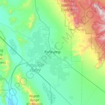
Name: Pahrump topographic map, elevation, terrain.
Location: Pahrump, Nye County, Nevada, United States (36.00121 -116.22802 36.40983 -115.89443)
Average elevation: 3,747 ft
Minimum elevation: 2,103 ft
Maximum elevation: 10,335 ft
Nye County trails, hiking, mountain biking, running and outdoor activities
Other topographic maps
Click on a map to view its topography, its elevation and its terrain.
Mercury
United States > Nevada > Nye County
In 1957, the US Navy launched nine atmospheric sounding rockets to measure nuclear radiation and other atmospheric data, using Mercury as a staging area. The Naval Radiological Defense Laboratory conducted its first test flight in 1956. This test rocket lifted 13.6 kilograms (30 lb) to an altitude of 40…
Average elevation: 3,881 ft