
Hays topographic map
Interactive map
Click on the map to display elevation.
About this map
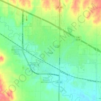
Name: Hays topographic map, elevation, terrain.
Location: Hays, Ellis County, Kansas, 67601, United States (38.84158 -99.36065 38.92042 -99.27552)
Average elevation: 2,047 ft
Minimum elevation: 1,965 ft
Maximum elevation: 2,201 ft
Hays is located at 38°52′46″N 99°19′20″W / 38.87944°N 99.32222°W / 38.87944; -99.32222 (38.879399, −99.322277) at an elevation of 2,024 feet (617 m). Located in northwestern Kansas at the intersection of Interstate 70 and U.S. Route 183, Hays is 134 miles (216 km) northwest of Wichita, 256 miles (412 km) west of Kansas City, and 311 miles (501 km) east-southeast of Denver.
Other topographic maps
Click on a map to view its topography, its elevation and its terrain.
Emmeram
United States > Kansas > Ellis County
Emmeram, Ellis County, Kansas, United States
Average elevation: 2,031 ft
Catharine
United States > Kansas > Ellis County
Catharine, Ellis County, Kansas, 67627, United States
Average elevation: 2,028 ft