Big Rapids topographic map
Interactive map
Click on the map to display elevation.
About this map
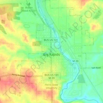
Name: Big Rapids topographic map, elevation, terrain.
Location: Big Rapids, Mecosta County, Michigan, 49307, United States (43.67484 -85.50410 43.72409 -85.45595)
Average elevation: 958 ft
Minimum elevation: 866 ft
Maximum elevation: 1,076 ft
Other topographic maps
Click on a map to view its topography, its elevation and its terrain.
Barryton
United States > Michigan > Mecosta County
Barryton, Fork Township, Mecosta County, Michigan, United States
Average elevation: 994 ft
Wheatland Township
United States > Michigan > Mecosta County
Wheatland Township, Mecosta County, Michigan, 49340, United States
Average elevation: 1,037 ft
Chippewa Township
United States > Michigan > Mecosta County
Chippewa Township, Mecosta County, Michigan, 49320, United States
Average elevation: 1,106 ft
Big Rapids Township
United States > Michigan > Mecosta County
Big Rapids Township, Mecosta County, Michigan, United States
Average elevation: 1,066 ft
Austin Township
United States > Michigan > Mecosta County
Austin Township, Mecosta County, Michigan, 49346, United States
Average elevation: 1,033 ft