
Make a donation
Gear up for your next adventure:
As an Amazon Associate, this site earns from qualifying purchases at no extra cost to you.
Bloomington topographic map
Click on the map to display elevation.
Gear up for your next adventure:
As an Amazon Associate, this site earns from qualifying purchases at no extra cost to you.
Bloomington
Bloomington is located at 40°29′03″N 88°59′37″W. The city is at an elevation of 797 feet (243 m) above sea level. According to the 2010 census, Bloomington has a total area of 27.229 square miles (70.52 km2), of which 27.22 square miles (70.50 km2) (or 99.97%) is land and 0.009 square miles (0.02 km2) (or 0.03%) is water.
Make a donation
Gear up for your next adventure:
As an Amazon Associate, this site earns from qualifying purchases at no extra cost to you.
About this map
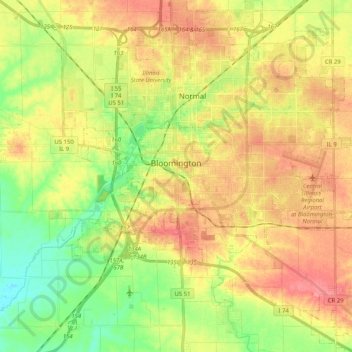
Name: Bloomington topographic map, elevation, terrain.
Location: Bloomington, McLean County, Illinois, United States (40.42944 -89.06772 40.51835 -88.86354)
Average elevation: 807 ft
Minimum elevation: 689 ft
Maximum elevation: 919 ft
McLean County trails, hiking, mountain biking, running and outdoor activities
Make a donation
Gear up for your next adventure:
As an Amazon Associate, this site earns from qualifying purchases at no extra cost to you.