
Make a donation
Gear up for your next adventure:
As an Amazon Associate, this site earns from qualifying purchases at no extra cost to you.
Blount County topographic map
Click on the map to display elevation.
Gear up for your next adventure:
As an Amazon Associate, this site earns from qualifying purchases at no extra cost to you.
Blount County
The southern part of Blount County is part of the Great Smoky Mountains, and is protected by the Great Smoky Mountains National Park. The crest of the range forms the county's border with Swain County, North Carolina, and includes Blount's highest point, 5,527-foot (1,685 m) Thunderhead Mountain, and the 4,949-foot (1,508 m) Gregory Bald, a prominent grassy bald. The northern part of the county is part of the Ridge-and-Valley Appalachians. The geologic boundary between the Blue Ridge (which includes the Smokies) and Ridge-and-Valley provinces runs along Chilhowee Mountain, a long and narrow ridge that stretches across the central part of the county. Much of Blount's topography is characterized by elongate ridges and rolling hills— known locally as "The Foothills"— which emanate outward from the Smokies range.
Make a donation
Gear up for your next adventure:
As an Amazon Associate, this site earns from qualifying purchases at no extra cost to you.
About this map
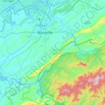
Name: Blount County topographic map, elevation, terrain.
Location: Blount County, East Tennessee, Tennessee, United States (35.46055 -84.18843 35.88713 -83.66320)
Average elevation: 1,480 ft
Minimum elevation: 801 ft
Maximum elevation: 5,420 ft
Tennessee trails, hiking, mountain biking, running and outdoor activities
Make a donation
Gear up for your next adventure:
As an Amazon Associate, this site earns from qualifying purchases at no extra cost to you.
Other topographic maps
Click on a map to view its topography, its elevation and its terrain.
Paschal Estates
United States > Tennessee > Rutherford County > Murfreesboro
Average elevation: 610 ft
Make a donation
Gear up for your next adventure:
As an Amazon Associate, this site earns from qualifying purchases at no extra cost to you.
Make a donation
Gear up for your next adventure:
As an Amazon Associate, this site earns from qualifying purchases at no extra cost to you.
Mount Le Conte
United States > Tennessee > Sevier County
Mount Le Conte (or LeConte) is a mountain located within the Great Smoky Mountains National Park in Sevier County, Tennessee. At 6,593 ft (2,010 m) it is the third highest peak in the national park, behind Kuwohi (formerly Clingmans Dome) (6,643 ft (2,025 m)) and Mount Guyot (6,621 ft (2,018 m)). It is also…
Average elevation: 5,449 ft
Country Club Estates
United States > Tennessee > Putnam County > Cookeville
Average elevation: 1,115 ft
Make a donation
Gear up for your next adventure:
As an Amazon Associate, this site earns from qualifying purchases at no extra cost to you.
Murray Lane Estates
United States > Tennessee > Williamson County > Brentwood
Average elevation: 787 ft
Stone Door Big Creek Gulf Overlook
United States > Tennessee > Grundy County
Average elevation: 1,604 ft
Make a donation
Gear up for your next adventure:
As an Amazon Associate, this site earns from qualifying purchases at no extra cost to you.
Make a donation
Gear up for your next adventure:
As an Amazon Associate, this site earns from qualifying purchases at no extra cost to you.
North Forrest bend beach
United States > Tennessee > Shelby County > Collierville
Average elevation: 299 ft
Make a donation
Gear up for your next adventure:
As an Amazon Associate, this site earns from qualifying purchases at no extra cost to you.
Signal Terrace
United States > Tennessee > Hamilton County > Signal Mountain
Average elevation: 1,686 ft
Make a donation
Gear up for your next adventure:
As an Amazon Associate, this site earns from qualifying purchases at no extra cost to you.
Make a donation
Gear up for your next adventure:
As an Amazon Associate, this site earns from qualifying purchases at no extra cost to you.
House Mountain
United States > Tennessee > Knox County
House Mountain is a mountain located in Corryton, Tennessee, United States, about 8 miles (13 km) northeast of Knoxville. Rising to an elevation of 2,064 feet (629 m) above sea level, House Mountain is the highest point in Knox County.
Average elevation: 1,293 ft
Make a donation
Gear up for your next adventure:
As an Amazon Associate, this site earns from qualifying purchases at no extra cost to you.
Shepherd Forest
United States > Tennessee > Hamilton County > Signal Mountain
Average elevation: 1,506 ft
Make a donation
Gear up for your next adventure:
As an Amazon Associate, this site earns from qualifying purchases at no extra cost to you.
Harpeth River Greenway
United States > Tennessee > Davidson County > Nashville > Harpeth River Estates
Average elevation: 597 ft
Make a donation
Gear up for your next adventure:
As an Amazon Associate, this site earns from qualifying purchases at no extra cost to you.
Make a donation
Gear up for your next adventure:
As an Amazon Associate, this site earns from qualifying purchases at no extra cost to you.
Make a donation
Gear up for your next adventure:
As an Amazon Associate, this site earns from qualifying purchases at no extra cost to you.
Bluegrass Meadows
United States > Tennessee > Sumner County > Hendersonville
Average elevation: 512 ft
Make a donation
Gear up for your next adventure:
As an Amazon Associate, this site earns from qualifying purchases at no extra cost to you.
Make a donation
Gear up for your next adventure:
As an Amazon Associate, this site earns from qualifying purchases at no extra cost to you.
Make a donation
Gear up for your next adventure:
As an Amazon Associate, this site earns from qualifying purchases at no extra cost to you.
Make a donation
Gear up for your next adventure:
As an Amazon Associate, this site earns from qualifying purchases at no extra cost to you.
Make a donation
Gear up for your next adventure:
As an Amazon Associate, this site earns from qualifying purchases at no extra cost to you.
Make a donation
Gear up for your next adventure:
As an Amazon Associate, this site earns from qualifying purchases at no extra cost to you.
Make a donation
Gear up for your next adventure:
As an Amazon Associate, this site earns from qualifying purchases at no extra cost to you.
Make a donation
Gear up for your next adventure:
As an Amazon Associate, this site earns from qualifying purchases at no extra cost to you.
Make a donation
Gear up for your next adventure:
As an Amazon Associate, this site earns from qualifying purchases at no extra cost to you.
Ellington Agricultural Center
United States > Tennessee > Davidson County > Nashville
Average elevation: 584 ft
Make a donation
Gear up for your next adventure:
As an Amazon Associate, this site earns from qualifying purchases at no extra cost to you.
Make a donation
Gear up for your next adventure:
As an Amazon Associate, this site earns from qualifying purchases at no extra cost to you.
Make a donation
Gear up for your next adventure:
As an Amazon Associate, this site earns from qualifying purchases at no extra cost to you.