
Moultrie topographic map
Interactive map
Click on the map to display elevation.
About this map
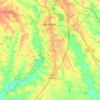
Name: Moultrie topographic map, elevation, terrain.
Location: Moultrie, Colquitt County, Georgia, United States (31.08647 -83.82410 31.20988 -83.69031)
Average elevation: 282 ft
Minimum elevation: 200 ft
Maximum elevation: 361 ft
Other topographic maps
Click on a map to view its topography, its elevation and its terrain.
Cool Springs
United States > Georgia > Colquitt County
Cool Springs, Colquitt County, Georgia, United States
Average elevation: 285 ft
Hartsfield
United States > Georgia > Colquitt County
Hartsfield, Colquitt County, Georgia, 31756, United States
Average elevation: 322 ft
Norman Park
United States > Georgia > Colquitt County > Norman Park > Norman Park
Norman Park, Colquitt County, Georgia, United States
Average elevation: 328 ft
Moultrie
United States > Georgia > Colquitt County > Moultrie > Moultrie
Moultrie, Colquitt County, Georgia, 31776, United States
Average elevation: 295 ft
Ellenton
United States > Georgia > Colquitt County
Ellenton, Colquitt County, Georgia, 31747, United States
Average elevation: 253 ft