
Pownal topographic map
Interactive map
Click on the map to display elevation.
About this map
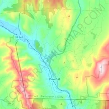
Name: Pownal topographic map, elevation, terrain.
Location: Pownal, Bennington County, Vermont, United States (42.74354 -73.29096 42.83933 -73.13711)
Average elevation: 1,211 ft
Minimum elevation: 459 ft
Maximum elevation: 2,723 ft
Bennington County trails, hiking, mountain biking, running and outdoor activities
Other topographic maps
Click on a map to view its topography, its elevation and its terrain.
Manchester Center
United States > Vermont > Bennington County > Manchester
Average elevation: 1,260 ft
Gale Meadows Pond
United States > Vermont > Bennington County > Winhall > French Hollow
Average elevation: 1,434 ft