
Make a donation
Gear up for your next adventure:
As an Amazon Associate, this site earns from qualifying purchases at no extra cost to you.
Burlington topographic map
Click on the map to display elevation.
Make a donation
Gear up for your next adventure:
As an Amazon Associate, this site earns from qualifying purchases at no extra cost to you.
Burlington
Located in the Greater Boston Area of eastern Massachusetts, Burlington is bordered by Bedford on the west, Billerica on the north, Wilmington on the northeast, Woburn on the southeast, and Lexington on the south. Burlington is 12 miles (19 km) south of Lowell, 12 miles (19 km) northwest of Boston, 36 miles (58 km) southeast of Fitchburg, and 224 miles (360 km) from New York City. Its highest point is Greenleaf Mountain (290 feet (88 m) above sea level), and its lowest point is the Great Meadow 150 feet (46 m) above sea level. The elevation at Town Hall is 220 feet (67 m) above sea level. The largest body of water is the 500-million-US-gallon (1,900,000 m3) Mill Pond Reservoir in the eastern part of the town.
Make a donation
Gear up for your next adventure:
As an Amazon Associate, this site earns from qualifying purchases at no extra cost to you.
About this map
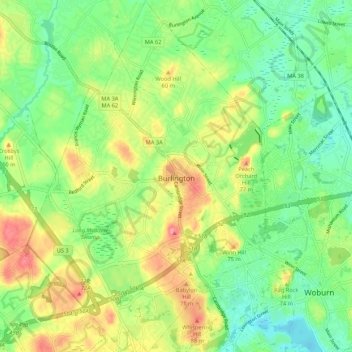
Name: Burlington topographic map, elevation, terrain.
Location: Burlington, Middlesex County, Massachusetts, United States (42.46584 -71.24091 42.54449 -71.16844)
Average elevation: 144 ft
Minimum elevation: 36 ft
Maximum elevation: 302 ft
Middlesex County trails, hiking, mountain biking, running and outdoor activities
Make a donation
Gear up for your next adventure:
As an Amazon Associate, this site earns from qualifying purchases at no extra cost to you.
Other topographic maps
Click on a map to view its topography, its elevation and its terrain.
Make a donation
Gear up for your next adventure:
As an Amazon Associate, this site earns from qualifying purchases at no extra cost to you.
North Chelmsford
United States > Massachusetts > Middlesex County > Chelmsford
Average elevation: 135 ft
Make a donation
Gear up for your next adventure:
As an Amazon Associate, this site earns from qualifying purchases at no extra cost to you.
Camp Kiwanis
United States > Massachusetts > Middlesex County > Tyngsborough
Average elevation: 217 ft
Make a donation
Gear up for your next adventure:
As an Amazon Associate, this site earns from qualifying purchases at no extra cost to you.
Make a donation
Gear up for your next adventure:
As an Amazon Associate, this site earns from qualifying purchases at no extra cost to you.
Medford Hillside
United States > Massachusetts > Middlesex County > Medford > West Medford
Average elevation: 43 ft
Hobbs Road
United States > Massachusetts > Middlesex County > Wayland > Cochituate
Average elevation: 217 ft
Make a donation
Gear up for your next adventure:
As an Amazon Associate, this site earns from qualifying purchases at no extra cost to you.
Make a donation
Gear up for your next adventure:
As an Amazon Associate, this site earns from qualifying purchases at no extra cost to you.
Make a donation
Gear up for your next adventure:
As an Amazon Associate, this site earns from qualifying purchases at no extra cost to you.
Make a donation
Gear up for your next adventure:
As an Amazon Associate, this site earns from qualifying purchases at no extra cost to you.
North Chelmsford
United States > Massachusetts > Middlesex County > Chelmsford
Average elevation: 135 ft
Make a donation
Gear up for your next adventure:
As an Amazon Associate, this site earns from qualifying purchases at no extra cost to you.
Arlington Heights
United States > Massachusetts > Middlesex County > Arlington
Average elevation: 190 ft
Melrose Highlands
United States > Massachusetts > Middlesex County > Melrose
Average elevation: 125 ft
Make a donation
Gear up for your next adventure:
As an Amazon Associate, this site earns from qualifying purchases at no extra cost to you.
Make a donation
Gear up for your next adventure:
As an Amazon Associate, this site earns from qualifying purchases at no extra cost to you.
Make a donation
Gear up for your next adventure:
As an Amazon Associate, this site earns from qualifying purchases at no extra cost to you.
Framingham Center
United States > Massachusetts > Middlesex County > Framingham
Average elevation: 190 ft
Make a donation
Gear up for your next adventure:
As an Amazon Associate, this site earns from qualifying purchases at no extra cost to you.
Glendale
United States > Massachusetts > Middlesex County > Everett > Glendale
Average elevation: 46 ft
Make a donation
Gear up for your next adventure:
As an Amazon Associate, this site earns from qualifying purchases at no extra cost to you.
East Acton
United States > Massachusetts > Middlesex County > Acton > East Acton
Average elevation: 174 ft
Cambridge
United States > Massachusetts > Middlesex County > Cambridge
Cambridge obtains water from Hobbs Brook (in Lincoln and Waltham) and Stony Brook (Waltham and Weston), as well as an emergency connection to the Massachusetts Water Resources Authority. The city owns over 1,200 acres (486 ha) of land in other towns that includes these reservoirs and portions of their…
Average elevation: 102 ft
Weston Station
United States > Massachusetts > Middlesex County > Weston > Weston Station
Average elevation: 180 ft
Make a donation
Gear up for your next adventure:
As an Amazon Associate, this site earns from qualifying purchases at no extra cost to you.