
Delafield topographic map
Interactive map
Click on the map to display elevation.
About this map
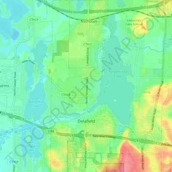
Name: Delafield topographic map, elevation, terrain.
Location: Delafield, Waukesha County, Wisconsin, 53018, United States (43.03960 -88.43006 43.10615 -88.34959)
Average elevation: 928 ft
Minimum elevation: 853 ft
Maximum elevation: 1,102 ft
Waukesha County trails, hiking, mountain biking, running and outdoor activities
Other topographic maps
Click on a map to view its topography, its elevation and its terrain.
Menomonee Falls
United States > Wisconsin > Waukesha County > Menomonee Falls
Average elevation: 853 ft