
Make a donation
Gear up for your next adventure:
As an Amazon Associate, this site earns from qualifying purchases at no extra cost to you.
Baxter State Park topographic map
Click on the map to display elevation.
Make a donation
Gear up for your next adventure:
As an Amazon Associate, this site earns from qualifying purchases at no extra cost to you.
Baxter State Park
After assuming the Maine Senate presidency during the state's 80th legislative session, Percival Baxter appointed his brother Rupert, a Senator from Sagadahoc County, to the Committee on State Lands and Forest Preservation, which would be considering legislation that would create a state park at Katahdin. Baxter introduced on January 25, 1921 “AN ACT to Establish the Mt. Katahdin State Park” (80th Legislature, Senate No. 19). The unexpected death of Governor Frederick H. Parkhurst on January 31, 1921 triggered Senate President Baxter’s elevation to the governorship. This unforeseen development dramatically changed the political fortunes of Baxter's park proposal. William F. Dawson's illustrated lecture, scheduled by Baxter for February 2, 1921, was cancelled, and in its stead legislators were filing past Parkhurst’s coffin laid out in the Capitol’s rotunda. Baxter, the newly inaugurated governor, was no longer able to direct legislative deliberations on his bill.
Make a donation
Gear up for your next adventure:
As an Amazon Associate, this site earns from qualifying purchases at no extra cost to you.
About this map
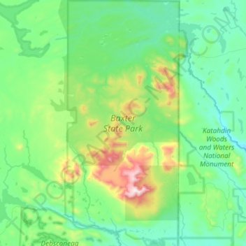
Name: Baxter State Park topographic map, elevation, terrain.
Location: Baxter State Park, Piscataquis County, Maine, United States (45.81423 -69.08618 46.21645 -68.76367)
Average elevation: 1,237 ft
Minimum elevation: 374 ft
Maximum elevation: 5,184 ft
Piscataquis County trails, hiking, mountain biking, running and outdoor activities
Make a donation
Gear up for your next adventure:
As an Amazon Associate, this site earns from qualifying purchases at no extra cost to you.
Other topographic maps
Click on a map to view its topography, its elevation and its terrain.
Fort Mountain
United States > Maine > Piscataquis County > T4 R10 WELS
On June 20, 1944, a C-54-A cargo plane on the Newfoundland to Washington, D.C. leg of trans-Atlantic TWA Flight 277 from England was pushed 70 miles (110 km) north of its planned course by stormy weather, which prevented obtaining visual or radio location fixes. The crew was unaware the aircraft had entered…
Average elevation: 3,097 ft
Mount Katahdin
United States > Maine > Piscataquis County > Mount Katahdin Township
It is commonly thought that Katahdin is the first place in the United States mainland to receive sunlight in the morning, but this is incorrect. Other mountains lower in elevation but farther to the east or southeast see the first sunrise of the day, depending on the season. Regardless, the summit of Katahdin…
Average elevation: 3,990 ft
Make a donation
Gear up for your next adventure:
As an Amazon Associate, this site earns from qualifying purchases at no extra cost to you.
Mount Katahdin
United States > Maine > Piscataquis County > Mount Katahdin Township
It is commonly thought that Katahdin is the first place in the United States mainland to receive sunlight in the morning, but this is incorrect. Other mountains lower in elevation but farther to the east or southeast see the first sunrise of the day, depending on the season. Regardless, the summit of Katahdin…
Average elevation: 3,990 ft