
Baxter State Park topographic map
Interactive map
Click on the map to display elevation.
Baxter State Park
After assuming the Maine Senate presidency during the state's 80th legislative session, Percival Baxter appointed his brother Rupert, a Senator from Sagadahoc County, to the Committee on State Lands and Forest Preservation, which would be considering legislation that would create a state park at Katahdin. Baxter introduced on January 25, 1921 “AN ACT to Establish the Mt. Katahdin State Park” (80th Legislature, Senate No. 19). The unexpected death of Governor Frederick H. Parkhurst on January 31, 1921 triggered Senate President Baxter’s elevation to the governorship. This unforeseen development dramatically changed the political fortunes of Baxter's park proposal. William F. Dawson's illustrated lecture, scheduled by Baxter for February 2, 1921, was cancelled, and in its stead legislators were filing past Parkhurst’s coffin laid out in the Capitol’s rotunda. Baxter, the newly inaugurated governor, was no longer able to direct legislative deliberations on his bill.
About this map
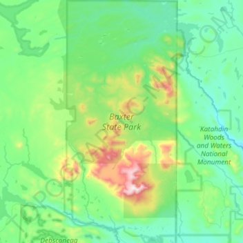
Name: Baxter State Park topographic map, elevation, terrain.
Average elevation: 1,237 ft
Minimum elevation: 374 ft
Maximum elevation: 5,184 ft
Piscataquis County trails, hiking, mountain biking, running and outdoor activities
Other topographic maps
Click on a map to view its topography, its elevation and its terrain.