
Americus topographic map
Interactive map
Click on the map to display elevation.
About this map
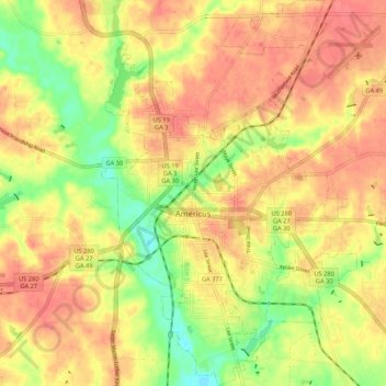
Name: Americus topographic map, elevation, terrain.
Location: Americus, Sumter County, Georgia, 31709, United States (32.03213 -84.25816 32.12218 -84.18748)
Average elevation: 410 ft
Minimum elevation: 285 ft
Maximum elevation: 489 ft
Other topographic maps
Click on a map to view its topography, its elevation and its terrain.
Concord
United States > Georgia > Sumter County
Concord, Sumter County, Georgia, United States
Average elevation: 495 ft
Northside Homes
United States > Georgia > Sumter County > Americus > Northside Homes
Northside Homes, Americus, Sumter County, Georgia, 31719, United States
Average elevation: 413 ft
Andersonville
United States > Georgia > Sumter County
Andersonville, Sumter County, Georgia, 31711, United States
Average elevation: 413 ft