
Aldo Leopold Wilderness topographic map
Interactive map
Click on the map to display elevation.
About this map
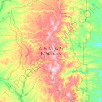
Name: Aldo Leopold Wilderness topographic map, elevation, terrain.
Average elevation: 7,379 ft
Minimum elevation: 5,561 ft
Maximum elevation: 10,141 ft
The Aldo Leopold Wilderness area stretches north-south along the crest of the Black Range for about 30 miles (48 km) and has a maximum width of about 15 miles (24 km). The elevation of the crest ranges from 8,600 to 10,165 feet (2,621 to 3,098 m) at McKnight Mountain, the highest point in the wilderness area. The crest of the range overlooks a series of east-west trending steep and narrow stream valleys, one thousand or more feet deep. The lowest elevation in the wilderness is about 6,000 feet (1,830 m). Vegetation in the Aldo Leopold consists of a spruce-fir and quaking aspen forest above 9,000 feet (2,740 m), a ponderosa pine forest between 6,500 and 9,000 feet (2,000 and 2,700 m) and a pinyon-juniper woodland and desert vegetation below 6,500 feet and on dry southern slopes. Hardwood forests, especially cottonwood, line many of the larger streams.
Other topographic maps
Click on a map to view its topography, its elevation and its terrain.
Silver City
United States > New Mexico > Grant County
Silver City, Grant County, New Mexico, 88062, United States
Average elevation: 6,070 ft
Hurley
United States > New Mexico > Grant County
Hurley, Grant County, New Mexico, United States
Average elevation: 5,689 ft
Bayard
United States > New Mexico > Grant County
Bayard, Grant County, New Mexico, 88023, United States
Average elevation: 5,958 ft
Arenas Valley
United States > New Mexico > Grant County > Silver City
Arenas Valley, Silver City, Grant County, New Mexico, 88022, United States
Average elevation: 6,145 ft
Santa Clara
United States > New Mexico > Grant County
Santa Clara, Grant County, New Mexico, 88026, United States
Average elevation: 6,014 ft
Mallet Pond
United States > New Mexico > Grant County
Mallet Pond, Grant County, New Mexico, United States
Average elevation: 5,912 ft
Dwyer
United States > New Mexico > Grant County
Dwyer, Grant County, New Mexico, 88034, United States
Average elevation: 5,302 ft
Pinos Altos
United States > New Mexico > Grant County
Pinos Altos, Grant County, New Mexico, 88053, United States
Average elevation: 7,028 ft