
Make a donation
Gear up for your next adventure:
As an Amazon Associate, this site earns from qualifying purchases at no extra cost to you.
Silver City topographic map
Click on the map to display elevation.
Make a donation
Gear up for your next adventure:
As an Amazon Associate, this site earns from qualifying purchases at no extra cost to you.
Silver City
During the period from 1901 to 1964 when readings were taken at the city center (which is cooler and wetter than outlying and lower-elevation districts nearby), the coldest temperature recorded was −13 °F (−25 °C) on January 11, 1962, and the hottest 105 °F (40.6 °C) on July 5, 1901. The coldest month was January 1949 with a monthly mean temperature of 28.7 °F or −1.8 °C, and the hottest July 1951 which averaged 77.4 °F or 25.2 °C. The wettest calendar year in this time span was 1914 with 24.97 inches or 634.2 millimetres and the driest 1947 with 6.77 inches or 172.0 millimetres. The most snow in one season was 48.0 inches or 1.22 metres between July 1912 and June 1913, which featured the coldest winter on record with 33.1 °F or 0.6 °C as the mean from December to February.
Make a donation
Gear up for your next adventure:
As an Amazon Associate, this site earns from qualifying purchases at no extra cost to you.
About this map
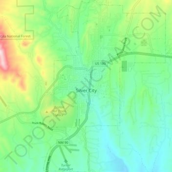
Name: Silver City topographic map, elevation, terrain.
Location: Silver City, Grant County, New Mexico, United States (32.73527 -108.29886 32.81071 -108.22398)
Average elevation: 6,070 ft
Minimum elevation: 5,686 ft
Maximum elevation: 7,005 ft
Grant County trails, hiking, mountain biking, running and outdoor activities
Make a donation
Gear up for your next adventure:
As an Amazon Associate, this site earns from qualifying purchases at no extra cost to you.
Other topographic maps
Click on a map to view its topography, its elevation and its terrain.
Make a donation
Gear up for your next adventure:
As an Amazon Associate, this site earns from qualifying purchases at no extra cost to you.
Basin and Range Country Historical Marker
United States > New Mexico > Grant County
Average elevation: 4,570 ft