
Meridian topographic map
Interactive map
Click on the map to display elevation.
Meridian
Meridian is located in the East Central Hills region of Mississippi in Lauderdale County. According to the United States Census Bureau, the city has a total area of 54.50 square miles (141.2 km2), of which 53.74 square miles (139.2 km2) are land and 0.76 square miles (2.0 km2), or 1.40%, are water. Along major highways, the city is 93 mi (150 km) east of Jackson, Mississippi; 154 mi (248 km) west of Birmingham, Alabama; 202 mi (325 km) northeast of New Orleans, Louisiana; 231 mi (372 km) southeast of Memphis, Tennessee; and 297 mi (478 km) west of Atlanta, Georgia. The area surrounding the city is covered with oak and pine forests, and its topography consists of clay hills and the bottom lands of the head waters of the Chickasawhay River.
About this map
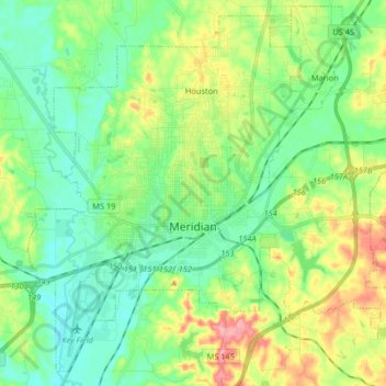
Name: Meridian topographic map, elevation, terrain.
Location: Meridian, Lauderdale County, Mississippi, United States (32.31238 -88.77360 32.43978 -88.61034)
Average elevation: 387 ft
Minimum elevation: 256 ft
Maximum elevation: 673 ft
Lauderdale County trails, hiking, mountain biking, running and outdoor activities
Other topographic maps
Click on a map to view its topography, its elevation and its terrain.