
Flowood topographic map
Interactive map
Click on the map to display elevation.
About this map
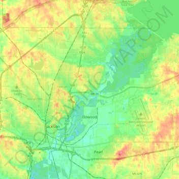
Name: Flowood topographic map, elevation, terrain.
Location: Flowood, Rankin County, Mississippi, United States (32.27837 -90.17958 32.39568 -89.96401)
Average elevation: 318 ft
Minimum elevation: 230 ft
Maximum elevation: 453 ft
Rankin County trails, hiking, mountain biking, running and outdoor activities
Other topographic maps
Click on a map to view its topography, its elevation and its terrain.
Hickory Glen
United States > Mississippi > Rankin County > Pearl > Hickory Glen
Average elevation: 302 ft