
Mossendjo topographic map
Interactive map
Click on the map to display elevation.
About this map
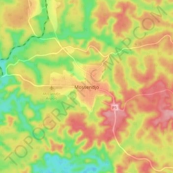
Name: Mossendjo topographic map, elevation, terrain.
Location: Mossendjo, Niari Department, Congo-Brazzaville (-2.98553 12.67528 -2.90553 12.75528)
Average elevation: 1,467 ft
Minimum elevation: 1,214 ft
Maximum elevation: 1,696 ft
Other topographic maps
Click on a map to view its topography, its elevation and its terrain.
Pangui
Congo-Brazzaville > Niari Department
Pangui, Niari Department, Congo-Brazzaville
Average elevation: 1,293 ft