Geolocate

Scottish Highlands topographic map

Interactive map

Click on the map to display elevation.

Scottish Highlands

The Scottish Highlands are renowned for their rugged, mountainous terrain that dominates much of the region. Stretching across the northern and central parts of Scotland, the landscape is shaped by ancient geological forces, including the Caledonian Orogeny, which caused significant tectonic collisions millions of years ago, uplifting the region's mountains. The Grampian Mountains and Cairngorms, part of the Highland Boundary Fault, form some of the highest peaks in the UK, including Ben Nevis, at 1,345 meters (4,413 feet). The region is dotted with steep valleys, or glens, carved by glaciers during the last ice age, alongside numerous lochs such as the famous Loch Ness. These glacial features give the Highlands a starkly dramatic topography, characterized by deep fjords, rolling hills, and vast moorlands, creating one of Europe's most distinctive landscapes.

About this map

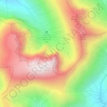
Name: Scottish Highlands topographic map, elevation, terrain.

Location: Scottish Highlands, Highland, Scotland, United Kingdom (56.79995 -5.00005 56.80005 -4.99995)

Average elevation: 2,976 ft

Minimum elevation: 1,542 ft

Maximum elevation: 4,390 ft

Other topographic maps

Click on a map to view its topography, its elevation and its terrain.

Portree

United Kingdom > Scotland > Highland

Average elevation: 397 ft

Skye

United Kingdom > Scotland > Highland

Beyond Loch Snizort to the west of Trotternish is the Waternish peninsula, which ends in Ardmore Point's double rock arch. Duirinish peninsula is separated from Waternish by Loch Dunvegan, which contains the island of Isay. It is ringed by sea cliffs that reach 296 metres (971 feet) on the west at Waterstein…

Average elevation: 207 ft

Laide

United Kingdom > Scotland > Highland

Average elevation: 154 ft

Inverness

United Kingdom > Scotland > Highland

Average elevation: 535 ft

Fortrose

United Kingdom > Scotland > Highland

Average elevation: 164 ft

Eilean Donan

United Kingdom > Scotland > Highland > Dornie > Totaig

In 1689, King James VII of the House of Stuart was declared to have to forfeit the throne, and the crown was offered to William of Orange, in the so-called "Glorious Revolution". The revolution also established Presbyterianism in Scotland, although the Highlands generally remained Roman Catholic and loyal to…

Average elevation: 269 ft

Redpoint

United Kingdom > Scotland > Highland

Average elevation: 121 ft

Sciberscross

United Kingdom > Scotland > Highland

Average elevation: 551 ft

Kilmory

United Kingdom > Scotland > Highland

Average elevation: 200 ft

Fodderty

United Kingdom > Scotland > Highland

Average elevation: 423 ft

Lewiston

United Kingdom > Scotland > Highland

Average elevation: 417 ft

Kingussie

United Kingdom > Scotland > Highland

Average elevation: 1,109 ft

Tornagrain

United Kingdom > Scotland > Highland > Inverness

Average elevation: 151 ft

Newtonmore

United Kingdom > Scotland > Highland

Newtonmore is located within the Cairngorms National Park, approximately 3 miles (5 km) southwest of Kingussie and 15 miles (24 km) southwest of Aviemore. It is on the northeastern bank of the River Spey, between the River Calder and the Allt Lairaidh, at an altitude of approximately 250 metres (820 ft).

Average elevation: 928 ft

Tornagrain

United Kingdom > Scotland > Highland

Average elevation: 167 ft

Loch Ness

United Kingdom > Scotland > Highland > Dores

Average elevation: 1,115 ft

Ullapool

United Kingdom > Scotland > Highland

Average elevation: 492 ft

Cairn Gorm

United Kingdom > Scotland > Highland

Cairn Gorm (Scottish Gaelic: An Càrn Gorm) is a mountain in the Scottish Highlands. It is part of the Cairngorms range and wider Grampian Mountains. With a summit elevation of 1,245 m (4,085 ft) above sea level, Cairn Gorm is classed as a Munro and is the sixth-highest mountain in the British Isles. The high,…

Average elevation: 3,245 ft

Buachaille Etive Mor

United Kingdom > Scotland > Highland

Average elevation: 1,857 ft

Struy

United Kingdom > Scotland > Highland

Average elevation: 538 ft

Ben Nevis

United Kingdom > Scotland > Highland

Ben Nevis has a highland (alpine) maritime (oceanic) polar climate (ET climate in the Köppen classification). Ben Nevis's elevation, maritime location and topography frequently lead to cool and cloudy weather conditions, which can pose a danger to ill-equipped walkers. According to the observations carried…

Average elevation: 2,992 ft

Tomnacross

United Kingdom > Scotland > Highland > Kiltarlity

Average elevation: 285 ft

Carbost

United Kingdom > Scotland > Highland

Average elevation: 361 ft

Craigton

United Kingdom > Scotland > Highland > North Kessock

Average elevation: 98 ft

Nairn

United Kingdom > Scotland > Highland

Average elevation: 59 ft

Lairg Muir

United Kingdom > Scotland > Highland > Lairg

Average elevation: 453 ft

Glen Hill

United Kingdom > Scotland > Highland

Average elevation: 673 ft

Dunvegan

United Kingdom > Scotland > Highland

Average elevation: 135 ft

Newport

United Kingdom > Scotland > Highland

Average elevation: 253 ft

Gairloch

United Kingdom > Scotland > Highland > Gairloch

Average elevation: 272 ft

Alvie

United Kingdom > Scotland > Highland > Alvie

Average elevation: 935 ft

Torlundy

United Kingdom > Scotland > Highland > Torlundy

Average elevation: 295 ft

Thurso

United Kingdom > Scotland > Highland

Average elevation: 82 ft

Salen

United Kingdom > Scotland > Highland > Salen

Average elevation: 272 ft

Pinnacle Ridge

United Kingdom > Scotland > Highland

Average elevation: 1,549 ft

Loch Toll an Lochain

United Kingdom > Scotland > Highland

Average elevation: 2,090 ft

Kyleakin

United Kingdom > Scotland > Highland > Kyleakin

Average elevation: 157 ft

Applecross

United Kingdom > Scotland > Highland

Average elevation: 489 ft

Attadale

United Kingdom > Scotland > Highland

Average elevation: 400 ft

Fort Augustus

United Kingdom > Scotland > Highland

As with most of the British Isles and Scotland, Fort Augustus has an oceanic climate (Köppen: Cfb) with cool summers and mild winters. Like a lot of the surrounding area, sunshine levels are low at around 1,000 hours per annum and temperatures are unpredictable – Fort Augustus holds the UK's joint lowest…

Average elevation: 377 ft

Kentallen

United Kingdom > Scotland > Highland

Average elevation: 669 ft

Mallaig

United Kingdom > Scotland > Highland

Average elevation: 82 ft