
Chestertown topographic map
Interactive map
Click on the map to display elevation.
About this map
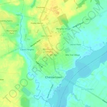
Name: Chestertown topographic map, elevation, terrain.
Location: Chestertown, Kent County, Maryland, 21620, United States (39.19851 -76.09469 39.23594 -76.04911)
Average elevation: 36 ft
Minimum elevation: 0 ft
Maximum elevation: 82 ft
Kent County trails, hiking, mountain biking, running and outdoor activities
Other topographic maps
Click on a map to view its topography, its elevation and its terrain.