
Make a donation
Gear up for your next adventure:
As an Amazon Associate, this site earns from qualifying purchases at no extra cost to you.
City of Ithaca topographic map
Click on the map to display elevation.
Make a donation
Gear up for your next adventure:
As an Amazon Associate, this site earns from qualifying purchases at no extra cost to you.
City of Ithaca
Ithaca is characterized by a diverse topography that significantly influences its natural environment and urban layout. Nestled at the southern tip of Cayuga Lake, the city features a floodplain area with an average elevation around 636 feet (194 meters) above sea level, though it rises to approximately 1,214 feet (370 meters) in its higher regions. The surrounding landscape is marked by steep hills and valleys formed by ancient glacial activity, which contribute to the area’s scenic gorges and waterfalls. The prominent geological formations include shale and limestone from the Genesee and Hamilton groups, which create dramatic cliffs along the lake and in the gorges, enhancing both the ecological diversity and the visual appeal of the region. This unique terrain not only supports various ecosystems but also poses challenges such as flooding in certain low-lying areas, influencing urban planning and development.
Make a donation
Gear up for your next adventure:
As an Amazon Associate, this site earns from qualifying purchases at no extra cost to you.
About this map
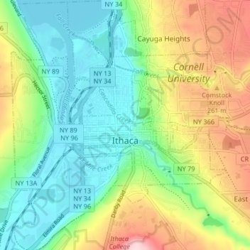
Name: City of Ithaca topographic map, elevation, terrain.
Location: City of Ithaca, Tompkins County, New York, United States (42.41816 -76.52700 42.46709 -76.46999)
Average elevation: 640 ft
Minimum elevation: 364 ft
Maximum elevation: 1,138 ft
Tompkins County trails, hiking, mountain biking, running and outdoor activities
Make a donation
Gear up for your next adventure:
As an Amazon Associate, this site earns from qualifying purchases at no extra cost to you.
Other topographic maps
Click on a map to view its topography, its elevation and its terrain.
Trumbull Corners
United States > New York > Tompkins County > Town of Newfield
Average elevation: 1,453 ft
Hartung-Boothroyd Observatory
United States > New York > Tompkins County > Town of Dryden > Varna
The primary 0.6m mirror was constructed from a Pyrex 1/8-scale test pouring as part of technology development for the Palomar Observatory 200-inch telescope. The mirror was polished and mounted in a lightweight tube in the late 1930s under Boothroyd's direction, but World War II deferred its planned use in a…
Average elevation: 1,565 ft
Make a donation
Gear up for your next adventure:
As an Amazon Associate, this site earns from qualifying purchases at no extra cost to you.