
Patras topographic map
Interactive map
Click on the map to display elevation.
Patras
A central feature of the urban geography of Patras is its division into upper and lower sections. This is the result of an interplay between natural geography and human settlement patterns; the lower section of the city (Kato Poli), which includes the 19th-century urban core and the port, is adjacent to the sea and stretches between the estuaries of the rivers of Glafkos and Haradros. It is built on what was originally a bed of river soils and dried-up swamps. The older upper section (Ano Poli) covers the area of the pre-modern settlement, around the Fortress, on what is the last elevation of Mount Panachaikon (1,926 m (6,319 ft)) before the Gulf of Patras.
About this map
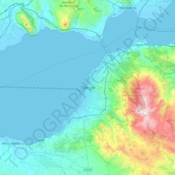
Name: Patras topographic map, elevation, terrain.
Average elevation: 928 ft
Minimum elevation: -16 ft
Maximum elevation: 6,293 ft
Other topographic maps
Click on a map to view its topography, its elevation and its terrain.
Municipal Unit of Patras
Greece > Peloponnese, Western Greece and the Ionian > Achaia Regional Unit
Average elevation: 1,821 ft
Municipality of Patras
Greece > Peloponnese, Western Greece and the Ionian > Achaia Regional Unit
A central feature of the urban geography of Patras is its division into upper and lower sections. This is the result of an interplay between natural geography and human settlement patterns; the lower section of the city (Kato Poli), which includes the 19th-century urban core and the port, is adjacent to the…
Average elevation: 955 ft