
Fresno topographic map
Interactive map
Click on the map to display elevation.
About this map
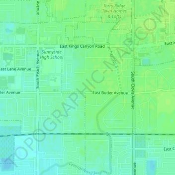
Name: Fresno topographic map, elevation, terrain.
Location: Fresno, Fresno County, California, United States (36.72845 -119.70935 36.73044 -119.70836)
Average elevation: 322 ft
Minimum elevation: 302 ft
Maximum elevation: 335 ft
Fresno County trails, hiking, mountain biking, running and outdoor activities
Other topographic maps
Click on a map to view its topography, its elevation and its terrain.
Kingsburg
United States > California > Fresno County
Kingsburg is a city in Fresno County, California. Kingsburg is located 5 miles (8 km) southeast of Selma at an elevation of 302 feet (92 m), on the banks of the Kings River. The city is 21 miles (34 km) from Fresno, and about 130 miles (210 km) from the California Central Coast and Sierra Nevada mountain…
Average elevation: 305 ft
Yokuts Valley
United States > California > Fresno County
As of the 2010 census, the CDP had a total population of 3,162, up from 2,691 at the 2000 census. Yokuts Valley is located 9 miles (14 km) north-northeast of Orange Cove and 30 miles (48 km) east of Fresno, at an elevation of 1,631 ft (497 m).
Average elevation: 1,808 ft
Orange Cove
United States > California > Fresno County
Almost all of Orange Cove's residents are Hispanic, many of them farmers. Orange Cove is located in the San Joaquin Valley, 8 miles (13 km) east-northeast of Reedley, at an elevation of 423 feet (129 m).
Average elevation: 433 ft
Laton
United States > California > Fresno County
Laton /ˈleɪtən/ is a census-designated place (CDP) in Fresno County, California, United States. The population was 1,824 at the 2010 census, up from 1,236 at the 2000 census. Laton is located 23 miles (37 km) south-southeast of Fresno, at an elevation of 259 feet (79 m).
Average elevation: 259 ft
Minkler
United States > California > Fresno County
Minkler is a census-designated place in eastern Fresno County, California. The place is located on Highway 180, 2.25 miles (3.6 km) east-southeast of Centerville and 7.6 miles north of Reedley at an elevation of 397 feet (121 m). It has a population of 1,003 people. The town is named for Charles O. Minkler, a…
Average elevation: 427 ft
Monmouth
United States > California > Fresno County
Monmouth is a census-designated place in Fresno County, California. It is located 7.25 miles (12 km) west of Selma, at an elevation of 276 feet (84 m). At the 2010 census, Monmouth had a population of 152.
Average elevation: 276 ft
Tranquillity
United States > California > Fresno County
Tranquillity is a census-designated place (CDP) in Fresno County, California, United States. It is located 10 miles (16 km) southeast of Mendota, at an elevation of 164 feet (50 m). The population was 799 at the 2010 census, down from 813 at the 2000 census. Tranquillity High School is the only high school in…
Average elevation: 161 ft
Burrel
United States > California > Fresno County
Burrel (formerly, Burrell) is an unincorporated community in Fresno County, California. It is located 30 miles (48 km) southwest of Fresno, at an elevation of 203 feet (62 m).
Average elevation: 200 ft
Pinedale
United States > California > Fresno County > Fresno
Pinedale is a previously unincorporated community in Fresno County, California. It lies at an elevation of 348 feet (106 m). It was once a rural community located on the Southern Pacific Railroad 3.5 miles (5.6 km) north-northwest of Clovis but has since become surrounded and annexed by the city of Fresno.…
Average elevation: 351 ft
Shaver Lake Heights
United States > California > Fresno County > Shaver Lake
Average elevation: 5,469 ft
Hume Lake
United States > California > Fresno County > Hume
The surface elevation of the lake is 1,586.34 m (5,204.5 ft). It is accessible from California Route 180, via Forest Service road 30, and is about 51 mi (82 km) east of Fresno, not far from the west entrance to Kings Canyon National Park.
Average elevation: 5,449 ft
Fowler
United States > California > Fresno County
Fowler (formerly, Fowler's Switch) is a city in Fresno County, California, United States. It is located within the San Joaquin Valley. It has a strong agricultural community, with lush grape vineyards and expansive farmland. Fowler is located 11 miles (18 km) southeast of downtown Fresno, at an elevation of…
Average elevation: 308 ft
Shaver Lake
United States > California > Fresno County
Shaver Lake (formerly, Musick Creek and Musick Creek Heights) is a census-designated place (CDP) in Fresno County, California, United States. The population was 634 at the 2010 census, down from 705 at the 2000 census. Shaver Lake is on the southwest end of the lake of the same name, 10 miles (16 km) east of…
Average elevation: 5,128 ft
Kerman
United States > California > Fresno County
Kerman (formerly Collis) is a city at the intersection of State Route 180 and State Route 145 in Fresno County, California, United States. The population was 13,544 at the 2010 census. Kerman is located 15 miles (24 km) west of Fresno, at an elevation of 220 feet (67 m).
Average elevation: 223 ft
Yokuts Valley
United States > California > Fresno County
Yokuts Valley (formerly, Squaw Valley) is a census-designated place located in Fresno County, California, in the United States. As of the 2010 census, the CDP had a total population of 3,162, up from 2,691 at the 2000 census. Yokuts Valley is located 9 miles (14 km) north-northeast of Orange Cove and 30 miles…
Average elevation: 1,434 ft
San Joaquin
United States > California > Fresno County
San Joaquin (Spanish: San Joaquín, meaning "St. Joachim") is a city in Fresno County, California, United States. The population was 4,001 at the 2010 census, up from 3,270 at the 2000 census. The nearest high school in the area is Tranquillity High School in Tranquillity. San Joaquin is located 11 miles (18…
Average elevation: 171 ft
Firebaugh
United States > California > Fresno County
Firebaugh lies at an elevation of 151 feet (46 m). The population was 7,549 at the 2010 census, up from 5,743 as of 2000.
Average elevation: 151 ft
Kaiser Wilderness
United States > California > Fresno County
The Kaiser Wilderness stretches along an east–west ridge and is separated from the High Sierra by the South Fork San Joaquin River canyon. It is a miniature version of the Sierra, with elevations from 7,200 feet (2,200 m) to 10,320 feet (3,150 m) at Kaiser Peak, and is composed of glacier-scoured granite…
Average elevation: 7,438 ft
Mendota
United States > California > Fresno County
Mendota is a U.S. city in Fresno County, California. The population was 11,014 at the 2010 U.S. Census. CA State Routes 180 and 33 run through the agricultural city. Mendota is located 8.5 miles (14 km) south-southeast of Firebaugh, at an elevation of 174 feet (53 m).
Average elevation: 171 ft
Parlier
United States > California > Fresno County
Parlier is a city in Fresno County, California, United States. As of the 2010 census, the city had a total population of 14,494, up from 11,145 in 2000. The city has one of the state's highest percentage of Latinos, a large majority of whom are seasonal migrant laborers who arrive and temporarily work in the…
Average elevation: 344 ft
Riverdale
United States > California > Fresno County
Riverdale (formerly, Liberty Settlement) is a census-designated place (CDP) in Fresno County, California, United States. The population was 3,153 at the 2010 census, up from 2,416 at the 2000 census. Riverdale is located 23 miles (37 km) south of Fresno, at an elevation of 223 ft (68 m).
Average elevation: 220 ft