
Arlington topographic map
Interactive map
Click on the map to display elevation.
Arlington
Arlington covers 3,517.5 acres (14 km2), or 5.5 square miles, of which 286.2 acres (1.2 km2), or 0.4 square miles, are covered by water. There are 210.52 acres (0.9 km2) of parkland. Elevation ranges from 4 feet (1.2 m) above sea level (along Alewife Brook) to 377 feet (114.9 m) near Park Avenue and Eastern Avenue.
About this map
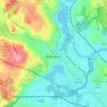
Name: Arlington topographic map, elevation, terrain.
Location: Arlington, Middlesex County, Massachusetts, United States (42.39741 -71.20264 42.43629 -71.13221)
Average elevation: 115 ft
Minimum elevation: 0 ft
Maximum elevation: 377 ft
Middlesex County trails, hiking, mountain biking, running and outdoor activities
Other topographic maps
Click on a map to view its topography, its elevation and its terrain.
North Chelmsford
United States > Massachusetts > Middlesex County > Chelmsford
Average elevation: 135 ft
Arlington Heights
United States > Massachusetts > Middlesex County > Arlington
Average elevation: 190 ft
Melrose Highlands
United States > Massachusetts > Middlesex County > Melrose
Average elevation: 125 ft
Cambridge
United States > Massachusetts > Middlesex County > Cambridge
Cambridge obtains water from Hobbs Brook (in Lincoln and Waltham) and Stony Brook (Waltham and Weston), as well as an emergency connection to the Massachusetts Water Resources Authority. The city owns over 1,200 acres (486 ha) of land in other towns that includes these reservoirs and portions of their…
Average elevation: 102 ft
Weston Station
United States > Massachusetts > Middlesex County > Weston > Weston Station
Average elevation: 180 ft
East Acton
United States > Massachusetts > Middlesex County > Acton > East Acton
Average elevation: 174 ft
Newton
United States > Massachusetts > Middlesex County > Newton
Newton has grown around a formation of seven hills. "The general features of Newton are not without interest. Seven principal elevations mark its surface, like the seven hills of ancient Rome, with the difference that the seven hills of Newton are much more distinct than the seven hills of Rome: Nonantum Hill,…
Average elevation: 141 ft
Glendale
United States > Massachusetts > Middlesex County > Everett > Glendale
Average elevation: 46 ft