
Fremont topographic map
Interactive map
Click on the map to display elevation.
Fremont
Centerville was the main town in Washington Township. Centerville is located at 37°33′15″N 121°59′57″W / 37.55417°N 121.99917°W / 37.55417; -121.99917 (Centerville). It lies at an elevation of 52 feet (16 m). Centerville was started by George Lloyd who started selling cold beer to stage passengers from a tent in 1850. Capt. George Bond set up a general store and the name Centerville was chosen. The post office opened Centreville post office in 1855 and changed the spelling to Centerville in 1893. The Centerville Pioneer Cemetery contains the burial places of many of the city's founding pioneers.
About this map
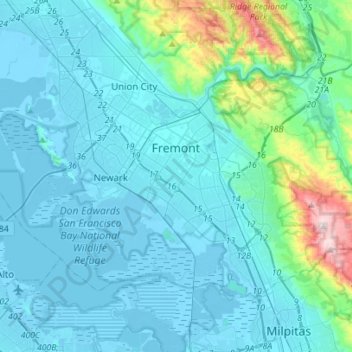
Name: Fremont topographic map, elevation, terrain.
Location: Fremont, Alameda County, California, United States (37.45426 -122.14891 37.60667 -121.87011)
Average elevation: 305 ft
Minimum elevation: -23 ft
Maximum elevation: 2,638 ft
Alameda County trails, hiking, mountain biking, running and outdoor activities
Other topographic maps
Click on a map to view its topography, its elevation and its terrain.
Contra Costa Rock Park
United States > California > Alameda County > Berkeley
Average elevation: 371 ft
Coyote Hills Regional Park
United States > California > Alameda County > Fremont
Average elevation: 16 ft