
Prineville topographic map
Interactive map
Click on the map to display elevation.
About this map
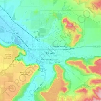
Name: Prineville topographic map, elevation, terrain.
Location: Prineville, Crook County, Oregon, United States (44.27194 -120.92143 44.33168 -120.80739)
Average elevation: 3,045 ft
Minimum elevation: 2,825 ft
Maximum elevation: 3,520 ft
Crook County trails, hiking, mountain biking, running and outdoor activities
Other topographic maps
Click on a map to view its topography, its elevation and its terrain.