
Williamsport topographic map
Click on the map to display elevation.
About this map
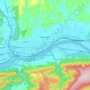
Name: Williamsport topographic map, elevation, terrain.
Location: Williamsport, Lycoming County, Pennsylvania, United States (41.21872 -77.09593 41.26456 -76.98168)
Average elevation: 830 ft
Minimum elevation: 489 ft
Maximum elevation: 2,018 ft
Lycoming County trails, hiking, mountain biking, running and outdoor activities
Other topographic maps
Click on a map to view its topography, its elevation and its terrain.
English Center
United States > Pennsylvania > Lycoming County > Pine Township
Average elevation: 1,457 ft
Waterville
United States > Pennsylvania > Lycoming County > Cummings Township
Average elevation: 1,273 ft
Elimsport
United States > Pennsylvania > Lycoming County > Washington Township
Average elevation: 630 ft
Lucullus
United States > Pennsylvania > Lycoming County > McHenry Township
Average elevation: 1,913 ft
Cogan Station
United States > Pennsylvania > Lycoming County > Hepburn Township
Average elevation: 794 ft
Cove Mountain
United States > Pennsylvania > Lycoming County > Gamble Township
Average elevation: 1,398 ft
Bastress
United States > Pennsylvania > Lycoming County > Bastress Township
Average elevation: 1,237 ft
Buttonwood
United States > Pennsylvania > Lycoming County > Jackson Township
Average elevation: 1,788 ft
Level Corner
United States > Pennsylvania > Lycoming County > Piatt Township
Average elevation: 725 ft
Raccoon Mountain
United States > Pennsylvania > Lycoming County > Armstrong Township
Average elevation: 1,243 ft
Loyalsockville
United States > Pennsylvania > Lycoming County > Upper Fairfield Township
Average elevation: 860 ft