
Corsicana topographic map
Interactive map
Click on the map to display elevation.
About this map
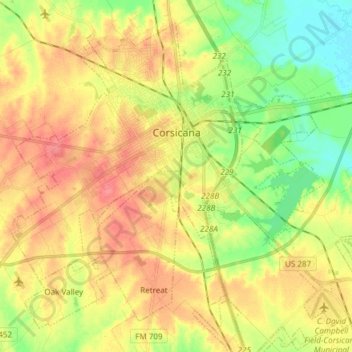
Name: Corsicana topographic map, elevation, terrain.
Location: Corsicana, Navarro County, Texas, United States (32.02000 -96.53532 32.13089 -96.38465)
Average elevation: 420 ft
Minimum elevation: 318 ft
Maximum elevation: 512 ft
Navarro County trails, hiking, mountain biking, running and outdoor activities
Other topographic maps
Click on a map to view its topography, its elevation and its terrain.