
Thank you for supporting this site ❤️
Make a donation
Make a donation
Gear up for your next adventure:
As an Amazon Associate, this site earns from qualifying purchases at no extra cost to you.
Appleton topographic map
Click on the map to display elevation.
Thank you for supporting this site ❤️
Make a donation
Make a donation
Gear up for your next adventure:
As an Amazon Associate, this site earns from qualifying purchases at no extra cost to you.
About this map
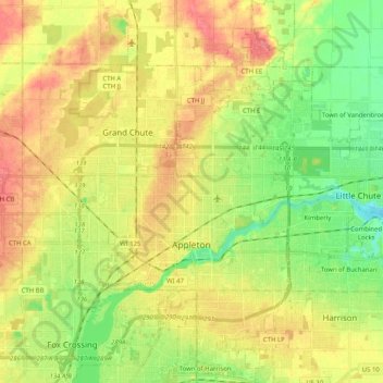
Name: Appleton topographic map, elevation, terrain.
Location: Appleton, Outagamie County, Wisconsin, United States (44.20866 -88.45158 44.35392 -88.34260)
Average elevation: 787 ft
Minimum elevation: 676 ft
Maximum elevation: 902 ft
Outagamie County trails, hiking, mountain biking, running and outdoor activities
Thank you for supporting this site ❤️
Make a donation
Make a donation
Gear up for your next adventure:
As an Amazon Associate, this site earns from qualifying purchases at no extra cost to you.
Other topographic maps
Click on a map to view its topography, its elevation and its terrain.