
Eau Claire topographic map
Interactive map
Click on the map to display elevation.
About this map
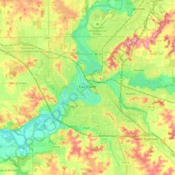
Name: Eau Claire topographic map, elevation, terrain.
Location: Eau Claire, Eau Claire County, Wisconsin, United States (44.74141 -91.59469 44.87921 -91.36788)
Average elevation: 902 ft
Minimum elevation: 732 ft
Maximum elevation: 1,119 ft
Eau Claire County trails, hiking, mountain biking, running and outdoor activities
Other topographic maps
Click on a map to view its topography, its elevation and its terrain.