
Make a donation
Gear up for your next adventure:
As an Amazon Associate, this site earns from qualifying purchases at no extra cost to you.
Milwaukee topographic map
Click on the map to display elevation.
Make a donation
Gear up for your next adventure:
As an Amazon Associate, this site earns from qualifying purchases at no extra cost to you.
Milwaukee
Milwaukee County is characterized by a gently rolling landscape that transitions into flatter terrain as it approaches Lake Michigan. The region's elevation varies modestly, with most areas ranging from about 600 to 700 feet above sea level. The county features several prominent water bodies, including the Milwaukee River and numerous smaller lakes, which contribute to the area's lush vegetation and biodiversity. Glacial activity during the last Ice Age shaped much of the topography, leaving behind rich alluvial plains and drumlins—hills formed by glacial debris. This varied terrain supports a mix of urban development, parks, and recreational areas, making Milwaukee an appealing location for residents and visitors alike.
Make a donation
Gear up for your next adventure:
As an Amazon Associate, this site earns from qualifying purchases at no extra cost to you.
About this map
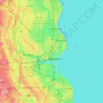
Name: Milwaukee topographic map, elevation, terrain.
Location: Milwaukee, Milwaukee County, Wisconsin, United States (42.92082 -88.07106 43.19494 -87.86271)
Average elevation: 673 ft
Minimum elevation: 564 ft
Maximum elevation: 961 ft
Milwaukee County trails, hiking, mountain biking, running and outdoor activities
Make a donation
Gear up for your next adventure:
As an Amazon Associate, this site earns from qualifying purchases at no extra cost to you.
Other topographic maps
Click on a map to view its topography, its elevation and its terrain.