
Morristown topographic map
Interactive map
Click on the map to display elevation.
Morristown
Morristown falls in the humid subtropical climate zone (Köppen climate classification Cfa), although it is not quite as hot as areas to the south and west of Tennessee due to the higher elevations. Summers are hot and humid, with July highs averaging 85 °F (29 °C), lows averaging 66 °F (19 °C), and an average of eight days per year with temperatures above 90 °F (32 °C). Winters are generally cool, with occasional small amounts of snow. January averages a high of around 45 °F (7 °C) and a low of around 28 °F (−2 °C), although low temperatures in the single digits and teens are not uncommon. The record high for Morristown, since 1994, is 103 °F (39 °C), while the record low is −2 °F (−19 °C). Annual precipitation averages around 44.3 in (1,125 mm), and average winter snowfall is 11.7 inches (30 cm). The average monthly relative humidity is around 70 percent.
About this map
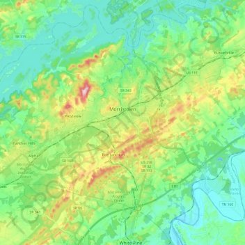
Name: Morristown topographic map, elevation, terrain.
Average elevation: 1,247 ft
Minimum elevation: 984 ft
Maximum elevation: 1,923 ft
Hamblen County trails, hiking, mountain biking, running and outdoor activities
Other topographic maps
Click on a map to view its topography, its elevation and its terrain.