
Make a donation
Gear up for your next adventure:
As an Amazon Associate, this site earns from qualifying purchases at no extra cost to you.
Tulsa topographic map
Click on the map to display elevation.
Make a donation
Gear up for your next adventure:
As an Amazon Associate, this site earns from qualifying purchases at no extra cost to you.
Tulsa
Tulsa, located in northeastern Oklahoma, is characterized by a diverse and rolling topography that marks its transition from the Great Plains to the Ozark foothills. The city's elevation averages around 700 feet (approximately 210 meters) above sea level, with some areas reaching heights of up to 1,050 feet (320 meters). This region, part of the ecoregion known as "Green Country," features a mix of forests and grasslands, supported by a relatively moist climate compared to other parts of Oklahoma. The landscape is punctuated by numerous lakes and rivers, adding to its scenic beauty and ecological variety. This combination of terrain provides a unique backdrop for the city, contributing to its reputation as one of the most topographically varied areas in the state.
Make a donation
Gear up for your next adventure:
As an Amazon Associate, this site earns from qualifying purchases at no extra cost to you.
About this map
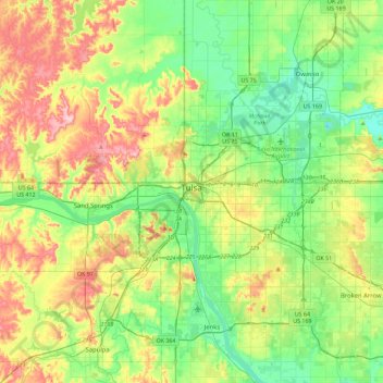
Name: Tulsa topographic map, elevation, terrain.
Location: Tulsa, Tulsa County, Oklahoma, United States (35.96830 -96.07448 36.33651 -95.68160)
Average elevation: 725 ft
Minimum elevation: 545 ft
Maximum elevation: 1,053 ft
Tulsa trails, hiking, mountain biking, running and outdoor activities
Make a donation
Gear up for your next adventure:
As an Amazon Associate, this site earns from qualifying purchases at no extra cost to you.
Other topographic maps
Click on a map to view its topography, its elevation and its terrain.