Geolocate

Isangel topographic map

Interactive map

Click on the map to display elevation.

About this map

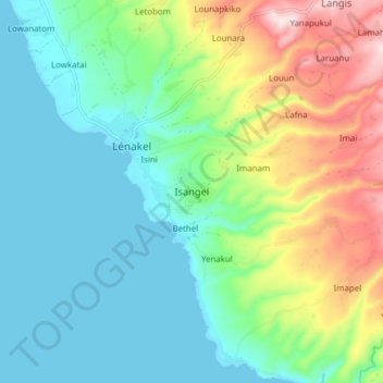
Name: Isangel topographic map, elevation, terrain.

Location: Isangel, Tafea, Vanuatu (-19.58109 169.24109 -19.50109 169.32109)

Average elevation: 367 ft

Minimum elevation: 0 ft

Maximum elevation: 1,273 ft

Other topographic maps

Click on a map to view its topography, its elevation and its terrain.

TAFEA Provincial Disaster Committee

Vanuatu > Tafea > Lénakel

TAFEA Provincial Disaster Committee, Nakepau, Lénakel, Tafea, Vanuatu

Average elevation: 240 ft

Anelghowat

Vanuatu > Tafea

Anelghowat, Tafea, Vanuatu

Average elevation: 236 ft

Unpongor

Vanuatu > Tafea

Unpongor, Tafea, Vanuatu

Average elevation: 535 ft

Enuahrat

Vanuatu > Tafea

Enuahrat, Tafea, Vanuatu

Average elevation: 899 ft

Ipikel

Vanuatu > Tafea

Ipikel, Tafea, Vanuatu

Average elevation: 240 ft

Futuna

Vanuatu > Tafea

Futuna, Tafea, Vanuatu

Average elevation: 489 ft

Erromango

Vanuatu > Tafea

Erromango, Tafea, Vanuatu

Average elevation: 387 ft