
Make a donation
Gear up for your next adventure:
As an Amazon Associate, this site earns from qualifying purchases at no extra cost to you.
Waterbury topographic map
Click on the map to display elevation.
Make a donation
Gear up for your next adventure:
As an Amazon Associate, this site earns from qualifying purchases at no extra cost to you.
About this map
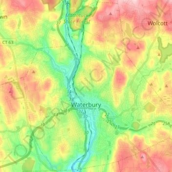
Name: Waterbury topographic map, elevation, terrain.
Average elevation: 548 ft
Minimum elevation: 200 ft
Maximum elevation: 981 ft
Naugatuck Valley Planning Region trails, hiking, mountain biking, running and outdoor activities
Make a donation
Gear up for your next adventure:
As an Amazon Associate, this site earns from qualifying purchases at no extra cost to you.
Other topographic maps
Click on a map to view its topography, its elevation and its terrain.
Huntington
United States > Connecticut > Naugatuck Valley Planning Region > Shelton
Average elevation: 364 ft
Minortown
United States > Connecticut > Naugatuck Valley Planning Region > Woodbury
Average elevation: 554 ft
White Hills
United States > Connecticut > Naugatuck Valley Planning Region > Shelton
Average elevation: 407 ft
Make a donation
Gear up for your next adventure:
As an Amazon Associate, this site earns from qualifying purchases at no extra cost to you.
Mad River
United States > Connecticut > Naugatuck Valley Planning Region > Waterbury > Fair Lawn
Average elevation: 440 ft
Fox Hollow
United States > Connecticut > Naugatuck Valley Planning Region > Cheshire
Average elevation: 210 ft
Westview Heights
United States > Connecticut > Naugatuck Valley Planning Region > Middlebury
Average elevation: 522 ft
Union City
United States > Connecticut > Naugatuck Valley Planning Region > Naugatuck
Average elevation: 407 ft
Make a donation
Gear up for your next adventure:
As an Amazon Associate, this site earns from qualifying purchases at no extra cost to you.
Warsaw Park
United States > Connecticut > Naugatuck Valley Planning Region > Ansonia
Average elevation: 351 ft
Bunker Hill
United States > Connecticut > Naugatuck Valley Planning Region > Waterbury
Average elevation: 459 ft
Cedar Land
United States > Connecticut > Naugatuck Valley Planning Region > Southbury
Average elevation: 338 ft
Town Plot Hill
United States > Connecticut > Naugatuck Valley Planning Region > Waterbury
Average elevation: 417 ft
Make a donation
Gear up for your next adventure:
As an Amazon Associate, this site earns from qualifying purchases at no extra cost to you.
Millville
United States > Connecticut > Naugatuck Valley Planning Region > Naugatuck
Average elevation: 433 ft
Bunker Hill
United States > Connecticut > Naugatuck Valley Planning Region > Waterbury
Average elevation: 459 ft
Bunker Hill
United States > Connecticut > Naugatuck Valley Planning Region > Waterbury
Average elevation: 459 ft
Traditions
United States > Connecticut > Naugatuck Valley Planning Region > Southbury > South Britain
Average elevation: 367 ft
Make a donation
Gear up for your next adventure:
As an Amazon Associate, this site earns from qualifying purchases at no extra cost to you.
Minortown
United States > Connecticut > Naugatuck Valley Planning Region > Woodbury
Average elevation: 554 ft
Gulls Hollow
United States > Connecticut > Naugatuck Valley Planning Region > Bethlehem
Average elevation: 797 ft
Allentown
United States > Connecticut > Naugatuck Valley Planning Region > Plymouth
Average elevation: 801 ft
Make a donation
Gear up for your next adventure:
As an Amazon Associate, this site earns from qualifying purchases at no extra cost to you.
Forestville
United States > Connecticut > Naugatuck Valley Planning Region > Bristol
Average elevation: 325 ft