
Make a donation
Gear up for your next adventure:
As an Amazon Associate, this site earns from qualifying purchases at no extra cost to you.
Las Cruces topographic map
Click on the map to display elevation.
Gear up for your next adventure:
As an Amazon Associate, this site earns from qualifying purchases at no extra cost to you.
Las Cruces
The approximate elevation of Las Cruces is 3,908 feet (1,191 m) above sea level.
Make a donation
Gear up for your next adventure:
As an Amazon Associate, this site earns from qualifying purchases at no extra cost to you.
About this map
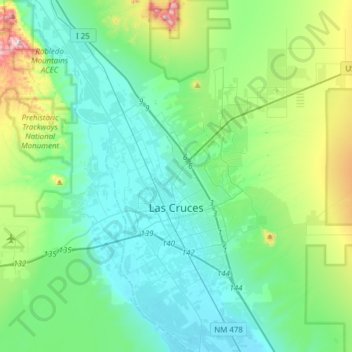
Name: Las Cruces topographic map, elevation, terrain.
Location: Las Cruces, Doña Ana County, New Mexico, United States (32.24229 -106.97329 32.43187 -106.66567)
Average elevation: 4,255 ft
Minimum elevation: 3,852 ft
Maximum elevation: 5,814 ft
Doña Ana County trails, hiking, mountain biking, running and outdoor activities
Make a donation
Gear up for your next adventure:
As an Amazon Associate, this site earns from qualifying purchases at no extra cost to you.
Other topographic maps
Click on a map to view its topography, its elevation and its terrain.
White Sands Missile Range
United States > New Mexico > Doña Ana County > White Sands
Average elevation: 4,285 ft
White Sands Missile Range
United States > New Mexico > Doña Ana County > White Sands
Average elevation: 4,285 ft
Make a donation
Gear up for your next adventure:
As an Amazon Associate, this site earns from qualifying purchases at no extra cost to you.