
Calais topographic map
Interactive map
Click on the map to display elevation.
About this map
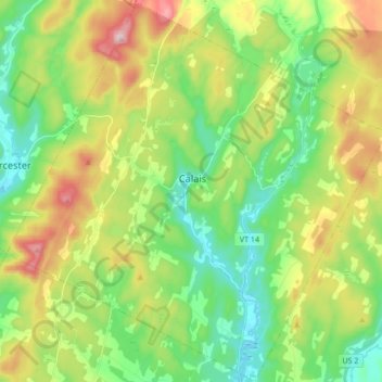
Name: Calais topographic map, elevation, terrain.
Location: Calais, Washington County, Vermont, United States (44.30449 -72.55078 44.42583 -72.37990)
Average elevation: 1,191 ft
Minimum elevation: 689 ft
Maximum elevation: 2,116 ft
Washington County trails, hiking, mountain biking, running and outdoor activities
Other topographic maps
Click on a map to view its topography, its elevation and its terrain.
North Montpelier
United States > Vermont > Washington County > East Montpelier
Average elevation: 912 ft