
Canton topographic map
Interactive map
Click on the map to display elevation.
About this map
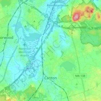
Name: Canton topographic map, elevation, terrain.
Location: Canton, Norfolk County, Massachusetts, 02021, United States (42.13770 -71.17804 42.22791 -71.06662)
Average elevation: 144 ft
Minimum elevation: 26 ft
Maximum elevation: 620 ft
Norfolk County trails, hiking, mountain biking, running and outdoor activities
Other topographic maps
Click on a map to view its topography, its elevation and its terrain.
Lake Massapoag
United States > Massachusetts > Norfolk County > Sharon
Because of the lake and the fact that Sharon is at a slightly higher elevation than the surrounding towns, and because it is located on the main rail line going south from Boston, the shores of the lake developed into a minor summer resort with several large hotels, summer camps and cottage colonies. Temple…
Average elevation: 276 ft
Clark Pond Reservoir
United States > Massachusetts > Norfolk County > Walpole
Average elevation: 213 ft
Crownridge Estates
United States > Massachusetts > Norfolk County > Medfield
Average elevation: 154 ft
Wrentham
United States > Massachusetts > Norfolk County > Wrentham > Wrentham
Average elevation: 259 ft
Wellesley Farms
United States > Massachusetts > Norfolk County > Wellesley > Wellesley Farms
Average elevation: 157 ft