
Make a donation
Gear up for your next adventure:
As an Amazon Associate, this site earns from qualifying purchases at no extra cost to you.
Barton Creek topographic map
Click on the map to display elevation.
Make a donation
Gear up for your next adventure:
As an Amazon Associate, this site earns from qualifying purchases at no extra cost to you.
About this map
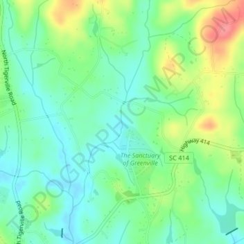
Name: Barton Creek topographic map, elevation, terrain.
Average elevation: 1,017 ft
Minimum elevation: 935 ft
Maximum elevation: 1,178 ft
Make a donation
Gear up for your next adventure:
As an Amazon Associate, this site earns from qualifying purchases at no extra cost to you.
Other topographic maps
Click on a map to view its topography, its elevation and its terrain.
Richard B. Russell Lake
United States of America > South Carolina > Barnes Station
Richard B. Russell Lake (known to locals as simply "Lake Russell") is a reservoir created by the U.S. Army Corps of Engineers by construction of Richard B. Russell Dam on the Savannah River bordering Elbert County, Georgia and Abbeville and Anderson counties in South Carolina. The lake impounds primarily the…
Average elevation: 591 ft