
Hillsboro Beach topographic map
Interactive map
Click on the map to display elevation.
About this map
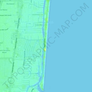
Name: Hillsboro Beach topographic map, elevation, terrain.
Location: Hillsboro Beach, Broward County, Florida, United States (26.25809 -80.08359 26.30532 -80.07625)
Average elevation: 10 ft
Minimum elevation: 0 ft
Maximum elevation: 59 ft
Broward County trails, hiking, mountain biking, running and outdoor activities
Other topographic maps
Click on a map to view its topography, its elevation and its terrain.
Fort Lauderdale Beach
United States > Florida > Broward County > Fort Lauderdale > Birch Ocean Front
Average elevation: 10 ft
Pompano Beach Highlands
United States > Florida > Broward County > Pompano Beach
Average elevation: 23 ft
Coral Ridge
United States > Florida > Broward County > Fort Lauderdale > Coral Ridge
Average elevation: 16 ft
Santa Barbara Shores
United States > Florida > Broward County > Pompano Beach
Average elevation: 16 ft
South Fork New River
United States > Florida > Broward County > Fort Lauderdale
Average elevation: 23 ft
Southwest Ranches
United States > Florida > Broward County > Southwest Ranches
Average elevation: 16 ft
Middle River Vista
United States > Florida > Broward County > Fort Lauderdale
Average elevation: 23 ft
Birch Ocean Front
United States > Florida > Broward County > Fort Lauderdale > Birch Ocean Front
Average elevation: 13 ft