
Cranberry Township topographic map
Interactive map
Click on the map to display elevation.
About this map
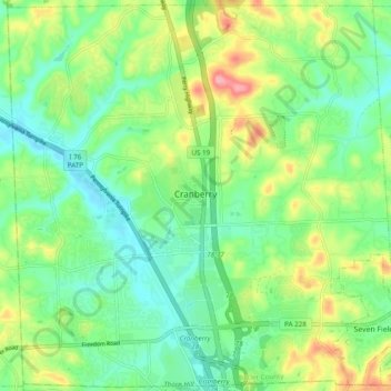
Name: Cranberry Township topographic map, elevation, terrain.
Average elevation: 1,119 ft
Minimum elevation: 974 ft
Maximum elevation: 1,404 ft
Butler County trails, hiking, mountain biking, running and outdoor activities
Other topographic maps
Click on a map to view its topography, its elevation and its terrain.
Bonnie Brook
United States > Pennsylvania > Butler County > Summit Township
Average elevation: 1,204 ft
Butler Farm Show Lake
United States > Pennsylvania > Butler County > Meridian
Average elevation: 1,286 ft