
Fredonia topographic map
Interactive map
Click on the map to display elevation.
About this map
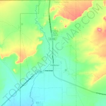
Name: Fredonia topographic map, elevation, terrain.
Location: Fredonia, Coconino County, Arizona, United States (36.91789 -112.54736 37.00083 -112.50398)
Average elevation: 4,800 ft
Minimum elevation: 4,613 ft
Maximum elevation: 5,200 ft
Fredonia is located at 36°56′58″N 112°31′18″W / 36.94944°N 112.52167°W / 36.94944; -112.52167 (36.949522, -112.521700), at 4,680 feet (1,430 m) in elevation. It is in the Arizona Strip, the portion of Arizona lying north of the Colorado River, and is within a few miles of the Utah border. According to the United States Census Bureau, the town has a total area of 7.4 square miles (19 km2), all land.
Other topographic maps
Click on a map to view its topography, its elevation and its terrain.
Flagstaff
United States > Arizona > Coconino County
Flagstaff, Coconino County, Arizona, United States
Average elevation: 7,139 ft
Grand Canyon
United States > Arizona > Coconino County
Grand Canyon, Coconino County, Arizona, United States
Average elevation: 3,350 ft
Williams
United States > Arizona > Coconino County
Williams, Coconino County, Arizona, 86046, United States
Average elevation: 6,991 ft
Antelope Canyon
United States > Arizona > Coconino County
Antelope Canyon, Coconino County, Arizona, United States
Average elevation: 3,953 ft
Bellemont
United States > Arizona > Coconino County
Bellemont, Coconino County, Arizona, 86015, United States
Average elevation: 7,201 ft
Oak Creek Vista
United States > Arizona > Coconino County
Oak Creek Vista, Old Highway Road, Coconino County, Arizona, United States
Average elevation: 6,437 ft
Flagstaff
United States > Arizona > Coconino County
Flagstaff, Coconino County, Arizona, United States
Average elevation: 7,057 ft
North Mesa
United States > Arizona > Coconino County
North Mesa, Coconino County, Arizona, United States
Average elevation: 5,276 ft
Mountainaire
United States > Arizona > Coconino County
Mountainaire, Coconino County, Arizona, United States
Average elevation: 6,906 ft
Great Thumb Mesa
United States > Arizona > Coconino County
Great Thumb Mesa, Coconino County, Arizona, United States
Average elevation: 6,211 ft
Forest Lakes Estates
United States > Arizona > Coconino County
Forest Lakes Estates, Coconino County, Arizona, 85931, United States
Average elevation: 7,523 ft
Mount Floyd
United States > Arizona > Coconino County
Mount Floyd, Coconino County, Arizona, United States
Average elevation: 6,644 ft
Williams City Limits
United States > Arizona > Coconino County
Williams City Limits, Coconino County, Arizona, United States, Elk Ridge Ski Area
Average elevation: 7,759 ft
Upper Antelope Canyon
United States > Arizona > Coconino County
Upper Antelope Canyon, Coconino County, Arizona, United States
Average elevation: 4,551 ft
Parks
United States > Arizona > Coconino County
Parks, Coconino County, Arizona, 86018, United States
Average elevation: 7,133 ft
LeChee
United States > Arizona > Coconino County
LeChee, Western Navajo Agency, Coconino County, Arizona, United States
Average elevation: 4,318 ft
Valle/Grand Canyon Junction
United States > Arizona > Coconino County
Valle/Grand Canyon Junction, Coconino County, Arizona, United States
Average elevation: 5,991 ft
Tuba City
United States > Arizona > Coconino County > Tuba City
Tuba City, Coconino County, Arizona, 86045, United States
Average elevation: 4,905 ft
Jacob Lake
United States > Arizona > Coconino County
Jacob Lake, Coconino County, Arizona, United States
Average elevation: 7,881 ft
Munds Park
United States > Arizona > Coconino County
Munds Park, Coconino County, Arizona, 86017, United States
Average elevation: 6,722 ft
Grand Canyon Navajo Tribal Park
United States > Arizona > Coconino County
Grand Canyon Navajo Tribal Park, Western Navajo Agency, Coconino County, Arizona, United States
Average elevation: 5,984 ft
Antelope Canyon
United States > Arizona > Coconino County
Antelope Canyon, Coconino County, Arizona, United States
Average elevation: 3,944 ft
Western Navajo Agency
United States > Arizona > Coconino County
Western Navajo Agency, Coconino County, Arizona, United States
Average elevation: 5,745 ft
Cameron
United States > Arizona > Coconino County
Cameron, Coconino County, Arizona, United States
Average elevation: 4,367 ft
Taylor Basin Tank
United States > Arizona > Coconino County
Taylor Basin Tank, Coconino County, Arizona, United States
Average elevation: 4,803 ft
Sycamore Point
United States > Arizona > Coconino County
Sycamore Point, Coconino County, Arizona, United States
Average elevation: 5,512 ft
Supai
United States > Arizona > Coconino County > Supai
Supai, Coconino County, Arizona, United States
Average elevation: 4,144 ft
Beaver Falls
United States > Arizona > Coconino County
Beaver Falls, Coconino County, Arizona, United States
Average elevation: 3,379 ft
Flagstaff
United States > Arizona > Coconino County > Flagstaff
Flagstaff, Coconino County, Arizona, 86001, United States
Average elevation: 7,316 ft
South Rim
United States > Arizona > Coconino County
South Rim, Coconino County, Arizona, United States
Average elevation: 6,581 ft
Glen Canyon Dam
United States > Arizona > Coconino County
Glen Canyon Dam, Coconino County, Arizona, United States
Average elevation: 3,842 ft
Forest Lakes
United States > Arizona > Coconino County
Forest Lakes, Coconino County, Arizona, United States
Average elevation: 7,579 ft
Beacon Hill
United States > Arizona > Coconino County
Beacon Hill, Coconino County, Arizona, United States
Average elevation: 7,011 ft
Williams City Limits
United States > Arizona > Coconino County
Williams City Limits, Coconino County, Arizona, United States
Average elevation: 7,021 ft
Stoneman Lake
United States > Arizona > Coconino County
Stoneman Lake, Coconino County, Arizona, United States
Average elevation: 7,077 ft
Clints Well
United States > Arizona > Coconino County
Clints Well, Coconino County, Arizona, United States
Average elevation: 6,939 ft
Havasupai Gardens
United States > Arizona > Coconino County
Havasupai Gardens, Coconino County, Arizona, United States
Average elevation: 4,331 ft
Grand Canyon Village
United States > Arizona > Coconino County > Grand Canyon Village
Grand Canyon Village, Coconino County, Arizona, United States
Average elevation: 5,833 ft
South Rim
United States > Arizona > Coconino County > Grand Canyon Village
South Rim, Grand Canyon Village, Coconino County, Arizona, United States
Average elevation: 6,096 ft
Robbers Roost
United States > Arizona > Coconino County
Robbers Roost, Coconino County, Arizona, United States
Average elevation: 6,175 ft
Buffalo Park
United States > Arizona > Coconino County > Flagstaff
Buffalo Park, East Flagstaff, Flagstaff, Coconino County, Arizona, United States
Average elevation: 7,083 ft
Phantom Ranch
United States > Arizona > Coconino County
Phantom Ranch, Coconino County, Arizona, United States
Average elevation: 3,323 ft
Tonalea
United States > Arizona > Coconino County
Tonalea, Coconino County, Arizona, United States
Average elevation: 5,604 ft
Dripping Spring
United States > Arizona > Coconino County
Dripping Spring, Dripping Springs Trail, Coconino County, Arizona, United States
Average elevation: 6,165 ft
Cow Springs
United States > Arizona > Coconino County
Cow Springs, Western Navajo Agency, Coconino County, Arizona, United States
Average elevation: 5,866 ft
Navajo Viewpoint
United States > Arizona > Coconino County > Wahweap
Navajo Viewpoint, Lake Shore Drive, Wahweap, Coconino County, Arizona, United States
Average elevation: 3,862 ft
Kinnikinick Dam
United States > Arizona > Coconino County
Kinnikinick Dam, Coconino County, Arizona, United States
Average elevation: 7,054 ft
Elaine Castle
United States > Arizona > Coconino County
Elaine Castle, Coconino County, Arizona, United States
Average elevation: 6,132 ft
Desert View Point
United States > Arizona > Coconino County
Desert View Point, Coconino County, Arizona, United States
Average elevation: 6,621 ft
Lees Ferry
United States > Arizona > Coconino County
Lees Ferry, Coconino County, Arizona, United States
Average elevation: 3,638 ft