
Havasupai Gardens topographic map
Interactive map
Click on the map to display elevation.
About this map
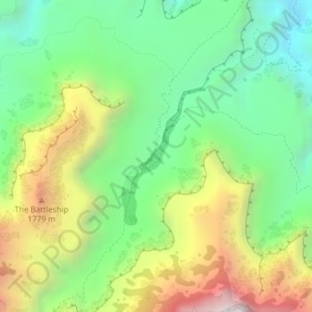
Name: Havasupai Gardens topographic map, elevation, terrain.
Location: Havasupai Gardens, Coconino County, Arizona, United States (36.07339 -112.12967 36.08531 -112.12092)
Average elevation: 4,331 ft
Minimum elevation: 2,651 ft
Maximum elevation: 7,051 ft
Coconino County trails, hiking, mountain biking, running and outdoor activities
Other topographic maps
Click on a map to view its topography, its elevation and its terrain.
Flagstaff
United States > Arizona > Coconino County
Flagstaff is the county seat of Coconino County. According to the United States Census Bureau, the city has a total area of 63.9 square miles (165.5 km2), of which only 0.03 square miles (0.08 km2) (0.08%) is water. Flagstaff lies at approximately 7,000 feet (2,130 m) elevation, and is surrounded by the…
Average elevation: 7,316 ft
Valle
United States > Arizona > Coconino County
Valle (Grand Canyon Junction) is a census-designated place in Coconino County, Arizona, United States. As of the 2010 US Census the population of Valle was 832. It lies at an altitude of 5,994 feet (1,827 m), at the junction of U.S. Route 180 and State Route 64. Its attractions include the Valle Airport (40G),…
Average elevation: 6,102 ft
Bellemont
United States > Arizona > Coconino County
Bellemont is an unincorporated community in Coconino County, Arizona, United States, located along Interstate 40, about 11 miles (18 km) west-northwest of Flagstaff. At an elevation of 7,132 feet (2,174 m), it is claimed to be the highest settlement along historic Route 66. It was a known water stop due to its…
Average elevation: 7,201 ft
Cameron
United States > Arizona > Coconino County
Cameron is located on the Navajo Nation. Elevation is 4,216 feet (1,285 m) above sea level. It is immediately south of the Little Colorado River, just above the beginning of the Little Colorado River Gorge and the stream's descent into the Grand Canyon. Cameron lies at the intersection of US 89 and State Route…
Average elevation: 4,367 ft
South Rim
United States > Arizona > Coconino County > Grand Canyon Village
Average elevation: 6,096 ft
Page
United States > Arizona > Coconino County > Page
Unlike other cities in the area, Page was founded in 1957 as a housing community for workers and their families during the construction of nearby Glen Canyon Dam on the Colorado River. Its 17-square-mile (44 km2) site was obtained in a land exchange with the Navajo Nation. The city is perched atop Manson Mesa…
Average elevation: 4,075 ft
Fredonia
United States > Arizona > Coconino County
Fredonia is located at 36°56′58″N 112°31′18″W / 36.94944°N 112.52167°W / 36.94944; -112.52167 (36.949522, -112.521700), at 4,680 feet (1,430 m) in elevation. It is in the Arizona Strip, the portion of Arizona lying north of the Colorado River, and is within a few miles of the Utah border.…
Average elevation: 4,800 ft