
Signal Mountain topographic map
Interactive map
Click on the map to display elevation.
About this map
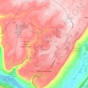
Name: Signal Mountain topographic map, elevation, terrain.
Average elevation: 1,617 ft
Minimum elevation: 627 ft
Maximum elevation: 2,090 ft
Hamilton County trails, hiking, mountain biking, running and outdoor activities
Other topographic maps
Click on a map to view its topography, its elevation and its terrain.
Brainerd
United States > Tennessee > Hamilton County > Chattanooga > Ridgeside
Average elevation: 768 ft
Mountain Ridge
United States > Tennessee > Hamilton County > Chattanooga > Red Bank
Average elevation: 817 ft
Wilder Point
United States > Tennessee > Hamilton County > Signal Mountain > Palisades
Average elevation: 1,342 ft
Carriage Hill
United States > Tennessee > Hamilton County > Signal Mountain
Average elevation: 1,283 ft
South Brainerd
United States > Tennessee > Hamilton County > Chattanooga > East Ridge
Average elevation: 732 ft
Regency Place
United States > Tennessee > Hamilton County > Chattanooga > Ridgeside
Average elevation: 768 ft
Soddy-Daisy
United States > Tennessee > Hamilton County > Soddy-Daisy > Soddy-Daisy
Average elevation: 1,007 ft
Northshore Estates
United States > Tennessee > Hamilton County > Chattanooga > Northshore Estates
Average elevation: 732 ft
Brookfield
United States > Tennessee > Hamilton County > East Ridge > Brookfield
Average elevation: 771 ft