
Peace River topographic map
Interactive map
Click on the map to display elevation.
About this map
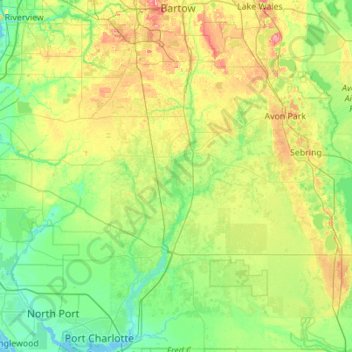
Name: Peace River topographic map, elevation, terrain.
Location: Peace River, Hardee County, Florida, United States (26.93714 -82.07308 27.91765 -81.77863)
Average elevation: 82 ft
Minimum elevation: -7 ft
Maximum elevation: 322 ft
Hardee County trails, hiking, mountain biking, running and outdoor activities
Other topographic maps
Click on a map to view its topography, its elevation and its terrain.