
Xuhui District topographic map
Interactive map
Click on the map to display elevation.
About this map
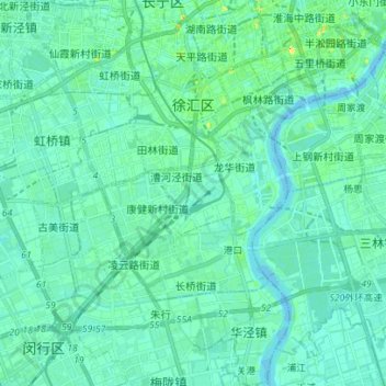
Name: Xuhui District topographic map, elevation, terrain.
Location: Xuhui District, Shanghai, China (31.10256 121.38688 31.22203 121.47193)
Average elevation: 20 ft
Minimum elevation: -13 ft
Maximum elevation: 118 ft
Other topographic maps
Click on a map to view its topography, its elevation and its terrain.
Shanghai
The golden age of Shanghai began with its elevation to municipality on 7 July 1927. This new Chinese municipality covered an area of 494.69 km2 (191.0 sq mi), including the modern-day districts of Baoshan, Yangpu, Zhabei, Nanshi, and Pudong, but excluded the foreign concessions territories. Headed by a Chinese…
Average elevation: 16 ft