
City of Glens Falls topographic map
Interactive map
Click on the map to display elevation.
About this map
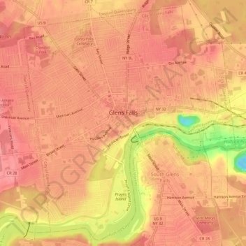
Name: City of Glens Falls topographic map, elevation, terrain.
Average elevation: 328 ft
Minimum elevation: 112 ft
Maximum elevation: 390 ft
Warren County trails, hiking, mountain biking, running and outdoor activities
Other topographic maps
Click on a map to view its topography, its elevation and its terrain.
Lake Vanare
United States > New York > Warren County > Town of Lake Luzerne
Average elevation: 1,014 ft
Diamond Point (hamlet)
United States > New York > Warren County > Town of Lake George
Average elevation: 627 ft
French Mountain
United States > New York > Warren County > Town of Queensbury
Average elevation: 1,040 ft
Bear Mountain
United States > New York > Warren County > Town of Stony Creek
Average elevation: 1,230 ft