
Hendersonville topographic map
Interactive map
Click on the map to display elevation.
Hendersonville
Hendersonville features a varied topography that enhances its appeal as a lakeside community. The area is predominantly characterized by gentle rolling hills and valleys that rise gradually from the shoreline of Old Hickory Lake, which itself covers approximately 22,000 acres. The elevation in Hendersonville typically ranges from about 500 to 800 feet above sea level, with certain higher points providing panoramic views of the surrounding landscape. This combination of hills and lakefront not only creates a picturesque environment but also supports diverse ecosystems and recreational opportunities, making it a desirable location for both residents and visitors.
About this map
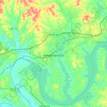
Name: Hendersonville topographic map, elevation, terrain.
Average elevation: 512 ft
Minimum elevation: 387 ft
Maximum elevation: 843 ft
Sumner County trails, hiking, mountain biking, running and outdoor activities
Other topographic maps
Click on a map to view its topography, its elevation and its terrain.
Lake Club Estates
United States > Tennessee > Sumner County > Hendersonville
Average elevation: 509 ft
Scottish Highlands
United States > Tennessee > Sumner County > Hendersonville
Average elevation: 515 ft
Curtiswood
United States > Tennessee > Sumner County > Hendersonville > Curtiswood
Average elevation: 472 ft