
Rimrock topographic map
Interactive map
Click on the map to display elevation.
About this map
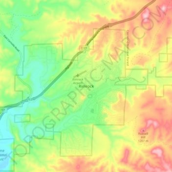
Name: Rimrock topographic map, elevation, terrain.
Location: Rimrock, Yavapai County, Arizona, 86342, United States (34.60504 -111.82484 34.68504 -111.74484)
Average elevation: 3,583 ft
Minimum elevation: 3,186 ft
Maximum elevation: 4,078 ft
Yavapai County trails, hiking, mountain biking, running and outdoor activities
Other topographic maps
Click on a map to view its topography, its elevation and its terrain.
Prescott
United States > Arizona > Yavapai County
Prescott is in the Bradshaw Mountains of central Arizona, at an elevation of 5,400 feet (1,600 m). The city has a Mediterranean climate (Köppen Csa); however, unlike most other locations in this climate class, there is a pronounced summer wet season due to the North American Monsoon.
Average elevation: 5,492 ft
Village of Oak Creek
United States > Arizona > Yavapai County
Big Park, Arizona (ZIP 86351), has a semi-arid climate (Köppen BSk) characterized by hot summers, mild winters, low humidity, and distinct wet and dry seasons. Its climate is shaped by its 4,000 ft (1,220 m) elevation, proximity to the Mogollon Rim, and surrounding red rock formations. Summers are hot but…
Average elevation: 4,373 ft
Chino Valley
United States > Arizona > Yavapai County
The town is in north-central Arizona, on state Highway 89, 15 miles (24 km) north of Prescott and 35 miles (56 km) south of Ash Fork, which is on Interstate 40. Chino Valley is at an elevation of about 4,750 feet (1,450 m).
Average elevation: 4,770 ft
Prescott
United States > Arizona > Yavapai County
Prescott is in the Bradshaw Mountains of central Arizona, at an elevation of 5,400 feet (1,600 m). The city has a Mediterranean climate (Köppen Csa) bordering on a Humid subtropical climate (Köppen Cwa); however, unlike most other locations in this climate class, there is a pronounced summer wet season due…
Average elevation: 5,492 ft
Chino Valley
United States > Arizona > Yavapai County
The town is in north-central Arizona, on state Highway 89, 15 miles (24 km) north of Prescott and 35 miles (56 km) south of Ash Fork, which is on Interstate 40. Chino Valley is at an elevation of about 4,750 feet (1,450 m).
Average elevation: 4,770 ft
Seligman
United States > Arizona > Yavapai County
Seligman is located at 35°19′42″N 112°52′27″W / 35.32833°N 112.87417°W / 35.32833; -112.87417 (35.328199, −112.874303), at 5,240 feet (1,600 m) in elevation, alongside the Big Chino Wash, in a northern section of Chino Valley. The wash is a major tributary of the Verde River. Seligman is…
Average elevation: 5,305 ft
Yarnell Hill Fire Memorial Park
United States > Arizona > Yavapai County > Yarnell
Average elevation: 4,915 ft
Seligman
United States > Arizona > Yavapai County
Seligman is located at 35°19′42″N 112°52′27″W / 35.32833°N 112.87417°W / 35.32833; -112.87417 (35.328199, −112.874303), at 5,240 feet (1,600 m) in elevation, alongside the Big Chino Wash, in a northern section of Chino Valley. The wash is a major tributary of the Verde River. Seligman is…
Average elevation: 5,305 ft
Tuzigoot National Monument
United States > Arizona > Yavapai County > Clarkdale
Average elevation: 3,428 ft
Jerome
United States > Arizona > Yavapai County
Jerome is about 100 miles (160 km) north of Phoenix and 45 miles (72 km) southwest of Flagstaff along Arizona State Route 89A between Sedona to the east and Prescott to the west. The town is in Arizona's Black Hills, which trend north–south. The town lies within the Prescott National Forest at an elevation…
Average elevation: 5,164 ft
Prescott Valley
United States > Arizona > Yavapai County
Prescott Valley (locally, PV) is located in central Arizona approximately 85 miles (137 km) north of Phoenix at 5,100 feet (1,600 m). elevation. PV has good access to Arizona State Route 89, SR-89A and SR-69, connecting to Interstates 17 and 40. Air service is available at Ernest A. Love Field, approximately 8…
Average elevation: 5,085 ft
Prescott
United States > Arizona > Yavapai County
Prescott is in the Bradshaw Mountains of central Arizona, at an elevation of 5,400 feet (1,600 m). The city has a Mediterranean climate (Köppen Csa); however, unlike most other locations in this climate class, there is a pronounced summer wet season due to the North American Monsoon.
Average elevation: 5,492 ft