
Gear up for your next adventure:
As an Amazon Associate, this site earns from qualifying purchases at no extra cost to you.
Make a donation
Ferreries topographic map
Click on the map to display elevation.
Gear up for your next adventure:
As an Amazon Associate, this site earns from qualifying purchases at no extra cost to you.
Gear up for your next adventure:
As an Amazon Associate, this site earns from qualifying purchases at no extra cost to you.
Make a donation
Ferreries
Ferreries is a municipality on the island of Menorca, in the Spanish autonomous community of the Balearic Islands. Its name is derived from the Catalan word ferrer ("blacksmith"), which in turn, comes from Latin word ferrum. At an elevation of 150 metres it is the island's highest town. Plaça Espanya
Gear up for your next adventure:
As an Amazon Associate, this site earns from qualifying purchases at no extra cost to you.
Make a donation
About this map
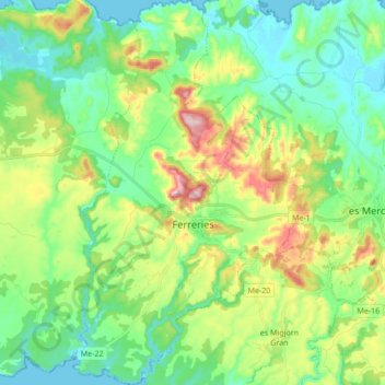
Name: Ferreries topographic map, elevation, terrain.
Location: Ferreries, Menorca, Balearic Islands, 07750, Spain (39.92902 3.95743 40.05963 4.06378)
Average elevation: 269 ft
Minimum elevation: 0 ft
Maximum elevation: 879 ft
Gear up for your next adventure:
As an Amazon Associate, this site earns from qualifying purchases at no extra cost to you.
Make a donation